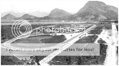
Had a road circuit and drag strip.
1995 Image

2007 Image

Best memory of Green Valley and it hangs on my wall:
http://www.shelbyame...flyingr2002.jpg


Member
Posted 15 February 2009 - 13:10
Advertisement
Member
Posted 15 February 2009 - 13:23


Member
Posted 15 February 2009 - 13:37

Member
Posted 15 February 2009 - 13:53

Member
Posted 15 February 2009 - 14:33

Member
Posted 15 February 2009 - 15:45

Member
Posted 15 February 2009 - 15:50


Member
Posted 15 February 2009 - 15:58
That's the old "Good Time Driving Park", mainly for horses, but held a few Big Car events in the thirties and forties.Originally posted by HistoricMustang
Need help on this mystery track for me.
Heard there was a triangle track in Goshen, New York (USA).
Name and history would be appreciated.
Henry


Member
Posted 15 February 2009 - 16:01
Originally posted by Barry Boor
When would works Ducatis have been at Brands?
Member
Posted 15 February 2009 - 16:18


Member
Posted 15 February 2009 - 16:48
Originally posted by Barry Boor
Definitely not O.T. but away from the recent trend of this thread, I wonder if anyone has had occasion to look at Brands Hatch on Google MAPS?
There is obviously quite a big event going on - the car parks are very full and there is a line of trucks pulled up to the back of the pits; the main paddock looks very full but there is no sign of a racing car, or for that matter, a racing bike.
There seems to be a person on the track just before Graham Hill Bend and a red vehicle approaching the bridge before Hawthorn's. There is also a lorry near Dingle Dell Corner.
I suppose the clue is that I have just spotted the word DUCATI on the roof of one of the transporters.
When would works Ducatis have been at Brands?

Member
Posted 15 February 2009 - 17:01
Member
Posted 15 February 2009 - 17:07
Member
Posted 15 February 2009 - 19:28

Member
Posted 16 February 2009 - 20:45
Unfortunately, I can't view imageshack photos on my computer. So, I can't say for sure unless it's glaringly obvious (as I can only see the thumbnail posted here). Alviso does not look right...unless there has been a lot of recent change there. Alviso Speedway can be found using HistoricAerials.comOriginally posted by HistoricMustang
Feather River Raceway - Oraville, California (USA)
This may be the track. Only description I have was that it was a 5/8 mile triangle track near the river.
Henry
Member
Posted 16 February 2009 - 23:25

Member
Posted 19 February 2009 - 10:06
Member
Posted 19 February 2009 - 11:31
Originally posted by Paul Hurdsfield
Not quite a racetrack but if you search Google Earth by UK postcode M125BH and zoom in, It's an industrial area and shows the factory where I work, and you can see my Yellow Westfied in the car park, It's not the clearest view, and It's at least two years ago.

Member
Posted 19 February 2009 - 12:30
Advertisement

Member
Posted 19 February 2009 - 13:18
Originally posted by Terry Walker
On another thread some time ago, we were all directed to a particular spot in UK by Google Earth, and there was a four engine WW2 bomber flying over the city. I wish I'd kept a copy of the shot. Apparently the coverage has since been updated and the plane is gone. But what are the odds?
Member
Posted 19 February 2009 - 22:07
Originally posted by Terry Walker
On another thread some time ago, we were all directed to a particular spot in UK by Google Earth, and there was a four engine WW2 bomber flying over the city. I wish I'd kept a copy of the shot. Apparently the coverage has since been updated and the plane is gone. But what are the odds?

Member
Posted 19 February 2009 - 22:26
Member
Posted 20 February 2009 - 00:42

New Member
Posted 20 February 2009 - 13:30
New Member
Posted 20 February 2009 - 14:27
Member
Posted 22 February 2009 - 01:16
Henry, thanks for the photo from OrovilleOriginally posted by HistoricMustang
Feather River Raceway - Oraville, California (USA)
This may be the track. Only description I have was that it was a 5/8 mile triangle track near the river.
Member
Posted 22 February 2009 - 12:20


Member
Posted 22 February 2009 - 21:54

Member
Posted 23 February 2009 - 18:07


Member
Posted 23 February 2009 - 22:10
Member
Posted 23 February 2009 - 23:15
Originally posted by TheStranger
Jim and Henry:
I've started a thread over at the Hoserforums Northern California Sprint Car forum after seeing your posts and got a little more information on the Oroville track from one of the members there:
http://www.hoseheadf...tm#thread140990


Member
Posted 24 February 2009 - 07:57
Henry, yes...there are many tracks so obscure as to be all but forgotten except by a few old timers in the area at the time. It's sadly common, and getting more so as time passes.Originally posted by HistoricMustang
Thanks Chris!
Surely the members are not stumped on this simple track?
From the TrackForum.com members:
"Not to veer a bit OT, but as far as photos of California tracks, there is only one known photo apiece of Ash Can Derby near San Bernardino and Feather River Raceway in Oroville. The Oroville shot was a demo run taken by the photog for the Mercury-Register. A 5/8 mile dirt triangle."
Lets find a photograph of this track for Jim! the Mercury-Register is the local newspaper for Oroville, California (USA).
This is a real mystery track so begin digging gentlemen! I necessary we will start a seperate thread to locate information.
 (I had spent too much time earlier at the Marysville library, looking up the Peach Bowl and Sierra Mesa!) I just find it amusing that my own info and research has reached far enough to come back to me! I guess I've accomplished something.
Member
Posted 24 February 2009 - 10:13


New Member
Posted 02 March 2009 - 15:00
Member
Posted 02 March 2009 - 21:00


New Member
Posted 02 March 2009 - 22:59
Member
Posted 02 March 2009 - 23:03
Originally posted by Great Zapper
I've spotted a couple of shots where the dates are different by a year or two but they are clearly the same picture from the traffic. All that's different is the colour balance, contrast and/or brightness are tweaked. Odd.
Member
Posted 03 March 2009 - 22:43


Member
Posted 03 March 2009 - 22:55

Advertisement

Member
Posted 03 March 2009 - 23:25

Member
Posted 04 March 2009 - 01:30
If you search for 'marlboro race track road, upper marlboro, md', on maps.live.com, you'll find that the oval and most of the old track is still there or thereabouts (click on 'Aerial' first, then 'Bird's eye' and you'll get the clearest, most recent view). Henry's the expert, though, so I'll leave him to post the image - these searches for the old raceways are fascinating!Originally posted by Doug Nye
OK - does much remain of the Marlboro 12-Hour race venue? Or has this been presented here already?
DCN
Member
Posted 04 March 2009 - 10:11
Originally posted by Doug Nye
OK - does much remain of the Marlboro 12-Hour race venue? Or has this been presented here already?
DCN
Member
Posted 04 March 2009 - 20:48

Member
Posted 04 March 2009 - 21:02

Member
Posted 04 March 2009 - 21:54

Member
Posted 04 March 2009 - 22:09

Member
Posted 04 March 2009 - 22:18

Member
Posted 04 March 2009 - 22:41

Member
Posted 04 March 2009 - 22:47
Henry - I was just trying to help out last night, but I was away off on the wrong tack (/track!) - the wrong side of Route 301! I didn't know you'd already covered it, but I see where it is now. From the image posted by Mark A on the other thread and the link you posted, it's all still there, right enough. Here's a recent photo of the oval centre section from maps.live.com - the raceway is sadly neglected, but almost entirely intact:Originally posted by HistoricMustang
We have already paid homage to this track.
http://forums.autosp...hlight=marlboro
Henry
 ), but no visible trace of the track.
Member
Posted 05 March 2009 - 09:57


© MOTORSPORT NETWORK 2024. All rights reserved. Community Forum Software by IP.Board
