Seeking Snetterton
#1
Posted 26 June 2012 - 11:11
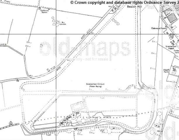
Up to the hairpin and back down Home Straight is fairly clear but at that point I seem to be a tad confused (what's new?).
All the circuit plans I can find of the old circuit show a fairly sharp left hander followed by a short straight and then a similarly sharp right hander - called The Esses - then a straight bit before the long Coram Curve, which itself ends in a gentle left curve onto the start-finish straight.
My problem is this, superimposing the modern circuit atop the line I have for the old one, the left and then right that led to the straight bit before Coram Curve begins, seem to be nothing like the old circuit plans. The section between the two parts of The Esses appears too short and nowhere near the angle that the old maps show it to be.
I am using Mark A's excellent work on Google Earth tracks as a base. I am wondering if the red line that is the old circuit should continue straight down until it meets the new (green) one at which point the left turn would be much sharper. It almost seems to me that the right hander of the old Esses and the straight down to Coram Curve should be much farther to the east than they are now. Incidentally, although we have had many people doubting the accuracy of measuring things on Google Eart, the red line circuit I have comes out at 2.66 miles as opposed to the 2.71 miles that it was officially listed as.
So, can any of you Snettexperts make a definitive judgement on this one
Advertisement
#2
Posted 26 June 2012 - 11:52
I am wondering if the red line that is the old circuit should continue straight down until it meets the new (green) one at which point the left turn would be much sharper.
Yes, it appears to be so ... the position of the bridge fixes the position of that part of the track.
See the 1978 1:2500 map here http://www.old-maps....s=600900,289525
#3
Posted 26 June 2012 - 12:05
Incidentally, although we have had many people doubting the accuracy of measuring things on Google Eart, the red line circuit I have comes out at 2.66 miles as opposed to the 2.71 miles that it was officially listed as.
So, can any of you Snettexperts make a definitive judgement on this one
The red line through the Old Russell corner is wrong on the Google Earth view. It was more of an Esses than shown there.
Yours truly in the middle of the corner and you can see it's much more of a curve.
Another view from the pitlane entrance. Russell Corner is in the background and it follows the path of the barriers.
Edited by alansart, 26 June 2012 - 12:06.
#4
Posted 26 June 2012 - 12:19
I am using Mark A's excellent work on Google Earth tracks as a base. I am wondering if the red line that is the old circuit should continue straight down until it meets the new (green) one at which point the left turn would be much sharper.
I think that could be correct. The bridge over the track used to be between the Esses and the Bombhole and the long circuit joined just before the bridge. You can see the bridge parapet in the background of this 1980 Julian Roberts photo and what looks like the remains of the long track behind which I think was used for runoff at the time.
I first raced at Snetterton in 1980 and the layout of the Esses and Bombhole look much the same as they are now.
#5
Posted 26 June 2012 - 12:56
#6
Posted 26 June 2012 - 13:44
In June 1965 the first change, the addition of Russell Bend, a tight chicane and the addition of the bailey bridge at the Esses, using earth for the ramps from the old wartime mound, that the USAF used for B17 gun firing butts. Gun alignment etc. That earth was then recycled for the new vehicle bridge we have today..still containing lead no doubt.
At the beginning of 1967, Russell was eased to the infamous ( but much missed ) almost flat kink.
The first major change was over the winter 1973-74. The circuit was shortened to 1.9 miles, the new
Revett Straight using the West-East runway, with a fast new Esses at the end. The tarmac run-off area at the end of this straight ( now the Bentley Straight ) was not originally laid onto the old runway as 'run-off', it was the 'bleach box' burn out area for the drag strip ( used 1974-1978 ), which ran the wrong way down the new straight towards Sear corner.
At the end of 1974 these new Esses bends were re-profiled following some nasty accidents, to the shape we have today. The new tighter version was designed by racer Peter Wardle. The old redundant hairpin area was used as a Rallycross track ( green line on map ). It featured a deep hole 'quarry' which the cars dived in and out of. Now the Sunday market occupies this space.
In 1990 Russell was re-profiled. The first new version was very tight, but eased after the first season of its use.
The most recent change, the new 2.99 mile '300' circuit, used for the first time in 2011.
Edited by Andrew Kitson, 26 June 2012 - 14:02.
#7
Posted 26 June 2012 - 13:59
(Copyright Old-maps.co.uk)
Paul M
#8
Posted 26 June 2012 - 16:15
Funnily enough, it still claims to be 70 yards too short!
#9
Posted 26 June 2012 - 20:35
Barry remember in the beginning the existing surfaces were used and where necessary the outer limits being defined with 5 gallon drums. The Hairpin was a point not a curve. The home straight followed the western side of the runway. Now the "Esses" the left was more open than the right in that the the straight came into the left hander before the intersection with the "east west" runway. This is difficult to describe but iirc 2/3 or 3/4 of the left hander would have been completed before crossing the northern side of the "east west" runway. Due to the mystical racing line there never was a straight between the 2 elements, however if I've got my scale right the displacement from the outsides of the 2 corners is about 180 yards.
#10
Posted 29 June 2012 - 16:02
Andrew K.,
can I offer my congratulations on a great job,makes the timeline much clearer. Also fills in a lot of gaps about the changes.
And Nick Wa,PLEASE don't call Time Team,snetterton ,s been dug up enough!
Regards,
carrotcruncher.
#11
Posted 29 June 2012 - 18:01
I guess it depends on how you measure the track length - Inside kerb, outside kerb or racing line (in which case - who's racing line do you use?)Thanks for all this Andrew (and Paul). I have realigned the red line on the Google Earth image and I reckon I've got it pretty close.
Funnily enough, it still claims to be 70 yards too short!
#12
Posted 29 June 2012 - 20:23
PLEASE don't call Time Team,snetterton ,s been dug up enough!
They'd inevitably find a bit of roman pot/tile and then probably create a 3D image of Castelfusano
#13
Posted 30 June 2012 - 01:04
You would have thought this was obvious but I've been trying to determine the exact position of the old Snetterton circuit in relation to the more modern version.
Bloody Monty Python. Ever since the Piranha Brothers, mention of Snetterton has brought to mind Vince Snetterton-Lewis, who fell foul of Doug and Dinsdale, viz:
"Well one day I was at home threatening the kids when I looks out through the hole in the wall and sees this tank pull up and out gets one of Dinsdale's boys, so he comes in nice and friendly and says Dinsdale wants to have a word with me, so he chains me to the back of the tank and takes me for a scrape round to Dinsdale's place and Dinsdale's there in the conversation pit with Doug and Charles Paisley, the baby crusher, and two film producers and a man they called 'Kierkegaard', who just sat there biting the heads of whippets and Dinsdale says 'I hear you've been a naughty boy Clement' and he splits me nostrils open and saws me leg off and pulls me liver out and I tell him my name's not Clement and then... he loses his temper and nails me head to the floor."
#14
Posted 30 June 2012 - 09:40
Spiny Norman possibly lives in the Bombhole.
#15
Posted 30 June 2012 - 13:22
#16
Posted 30 June 2012 - 14:29
IIRC it was due to the upgrading of the road (A11?) that runs parallel to the back straight and pretty close to the second corner. There were concerns about debris from an accident ending up on the road.This might be a stupid question, but why was the track shortened in the seventies?
#17
Posted 30 June 2012 - 19:22
#18
Posted 01 July 2012 - 09:33
Edited by LittleChris, 01 July 2012 - 09:33.
#19
Posted 01 July 2012 - 14:12
Whether the elimination of the hairpin was the driver for the circuit change I cannot say, but it was a result thereof.
Advertisement
#20
Posted 01 July 2012 - 19:33
#21
Posted 01 July 2012 - 19:51
Again, the straight could have been shortened, just like Montreal with the hairpin being shortened to create runoffs. Guess runoff areas was never heard of at the time!
Masten Gregory would've found them useful.
#22
Posted 02 July 2012 - 11:47
There was also a diminishing number of big meetings around that ' justified' a long lap.
A shorter track was simply easier on the pocket in the poor financial climate of the time(...how times change, yet stay the same!)