My wife bought me a copy of the Nye/Weguelin "Motorfilms Quarterly" Volume 20 which was issued earlier this year.
It has an original German language documentary on part of the 1938 racing season, some 26 mins long featuring the 1938 Avusrennen, German GP, bikes at the old Sachsenring and a mountainclimb featuring Grand Prix cars.
I was fascinated by the footage of the 1938 Avus races, firstly because I did not know that the event had taken place. Secondly, because the footage shows the cars and motorbikes using a shorter version of the track than had been used by the streamlined Grand Prix cars in 1937. In place of the South turn seen on the film of the 1937 Avusrennen there is a ultratight hairpin - little more than a simple connection between the 2 parallel straights. This may be the site of the Southcurve as used after WW2 - Can anyone confirm this?
The 1938 Avusrennen took place on 22 May 1938. Ther were several motorcycle races and a sportscar event featuring BMW328s. Does anyone have the results? They don't appear in the postwar Avus programmes or on the more obvious websites.
Happy Christmas to all TNFers
Tony

1938 Avusrennen
Started by
taylov
, Dec 25 2008 22:08
51 replies to this topic
Advertisement
#2

Vitesse2
-
- 41,859 posts
- Joined: April 01
Administrator
Posted 25 December 2008 - 22:33
The sports car race was won by Kurt Illmann.
1 Kurt Illmann (BMW) 154.100 km/h
2 Heinrich von der Mühle-Eckart (BMW)
3 Adolf Brudes (BMW)
4 Otto Trittel (BMW)
5 Carl von Langen (BMW)
etc
Source: http://new.racingspo...esults/BMW.html
Speed from "Rennen Reifen und Rekorde" by Richard Kitschigin.
1 Kurt Illmann (BMW) 154.100 km/h
2 Heinrich von der Mühle-Eckart (BMW)
3 Adolf Brudes (BMW)
4 Otto Trittel (BMW)
5 Carl von Langen (BMW)
etc
Source: http://new.racingspo...esults/BMW.html
Speed from "Rennen Reifen und Rekorde" by Richard Kitschigin.
#3
RStock
-
- 2,276 posts
- Joined: March 08
Member
Posted 25 December 2008 - 22:43
Originally posted by taylov
I was fascinated by the footage of the 1938 Avus races, firstly because I did not know that the event had taken place.
Here's just a bit of info , the only thing I could ever find about that race , Thanks Vitesse for the results .
This is from the 1939 German Magazine "The Street" . Poorly translated , I might add .
But despite their reconstruction, the good old Avus in Berlin from year to year, rising rates are not more recent demands of modern racing meet . 1938 saw the leader of the German driving force depends on the great racing, with its enormous top speeds on the train to hunt, only sports cars and motorcycles appeared at the start.
With this race, which in turn works of German and German sporting spirit witness, had the Avus begin their service terminated as a racetrack. In the 16 years of its history it has stages of development in the motor vehicle involved in the World admiration for the achievements German engineers and drivers abzwangen. Treu and brav has the further development of the engine served. These services are loyal to their now proud wage crowned.
Secondly, because the footage shows the cars and motorbikes using a shorter version of the track than had been used by the streamlined Grand Prix cars in 1937. In place of the South turn seen on the film of the 1937 Avusrennen there is a ultratight hairpin - little more than a simple connection between the 2 parallel straights. This may be the site of the Southcurve as used after WW2 - Can anyone confirm this?
Happy Christmas to all TNFers
Tony
I believe that turn had always been there , and had been used up until then only as a shorter course for motorcycles .
#4
onelung
-

- 546 posts
- Joined: November 07
Member
Posted 25 December 2008 - 23:09
Of possible interest or even of (some) value.
'21-'36 19.6km
'37-'39 19.3km
1937 I hope you have a wide screen monitor!
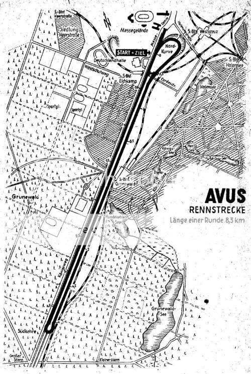
'51-'67 8.3km
8.3km
'68-'88 4.9km - does this mean the banking was no longer used? Or had it been removed...?
'92-'93 2.6km
2.6km
'94-'98 2.6km One suspects the last two can not have been exactly the same lap distance...?
'21-'36
 19.6km
'37-'39
 19.3km
1937
 I hope you have a wide screen monitor!
'51-'67
 8.3km
8.3km'68-'88
 4.9km - does this mean the banking was no longer used? Or had it been removed...?
'92-'93
 2.6km
2.6km'94-'98
 2.6km One suspects the last two can not have been exactly the same lap distance...?
#5
Vitesse2
-
- 41,859 posts
- Joined: April 01
Administrator
Posted 25 December 2008 - 23:24
According to Kitschigin, the 1938 circuit would seem to have been the same 8.3km layout as in 1951, being described as "Steilkurve, Südkehre mit Grossen Stern". That doesn't sound right, given Tony's description of a tight hairpin. So, like the 1937 version, the 1938 track may only have been used once?
And there's a sort of received wisdom that the post-war Avus was shortened because part of it was in East Berlin. Looks like that's another motor racing myth ....
And there's a sort of received wisdom that the post-war Avus was shortened because part of it was in East Berlin. Looks like that's another motor racing myth ....
#6
RStock
-
- 2,276 posts
- Joined: March 08
Member
Posted 26 December 2008 - 00:25
Originally posted by onelung
'68-'88
The banking in the Nordkurve was torn down in 1967 . It was relatively flat after the reconstuction .
#7
RStock
-
- 2,276 posts
- Joined: March 08
Member
Posted 26 December 2008 - 00:56
Originally posted by Vitesse2
According to Kitschigin, the 1938 circuit would seem to have been the same 8.3km layout as in 1951, being described as "Steilkurve, Südkehre mit Grossen Stern". That doesn't sound right, given Tony's description of a tight hairpin. So, like the 1937 version, the 1938 track may only have been used once?
I'm working on an assumption here , but I think that "tight hairpin" in the 38 race is the same one that had been in use on the shorter motorcycle course . A new , more proper south curve was reworked and first used in 51 . I'm also assumimg this is the same curve used in the 59 GP . Here's a photo of the south turn during the 59 GP .
click for large photo. >

What I don't know enough to even make an assumtion about is if this is where the hairpin was in the 38 race . The new curve built in 51 was about halfway down the straights . It would seem a likely spot for one in 38 , as the long straights of AVUS had been deemed unsafe for racing , but that may have applied only to GP cars .
#8
Catalina Park
-

- 6,774 posts
- Joined: July 01
Member
Posted 26 December 2008 - 06:50
I have been looking at Avus a bit of late. I was looking at where the border was and it is well outside of Avus, it is down the road and around a few bends. It is quite easy to find of Google Maps.Originally posted by Vitesse2
And there's a sort of received wisdom that the post-war Avus was shortened because part of it was in East Berlin. Looks like that's another motor racing myth ....
The hairpin has me wondering. I know what the 59 hairpin looked like and it is quite visible on the current photo but the later versions must had had a tight hairpin.
I found a clip on youtube showing the 1996 track... http://au.youtube.co...h?v=s6W-kmNZbWs this track looks very short.
#9
fines
-

- 9,647 posts
- Joined: September 00
Member
Posted 26 December 2008 - 09:30
East Berlin is (was!) quite some distance from where the AVUS is located, but post-WW2 the southern part of the track was in a different "sector", i.e. in the American, as opposed to the northern part in the British "sector"...;)Originally posted by Vitesse2
And there's a sort of received wisdom that the post-war Avus was shortened because part of it was in East Berlin. Looks like that's another motor racing myth ....
#10
taylov
-
- 624 posts
- Joined: February 05
Member
Posted 26 December 2008 - 09:32
Thank you all for the detailed replies and on Christmas Day too !!
On the location of the hairpin South Turn, I found a clue in the 1937 Avusrennen programme. The circuit map (which is not very clear) does show what appears to be a hairpin connection a little more than a third of the way down the track. The pattern of adjacent roads seems to place it at the same location as the South Turn of 1953.
The 1938 South Turn on the film does have a slightly widened entrance and exit (compared with the rest of the straights) but is not the faster turn used in 1958 and 1959 which can be seen on the same DVD in footage of Hans Hermann's flying BRM in the 1959 German GP and which is pictured above in REDARMYSOJA's posting.
Vitesse, many thanks for finding the result of the/a sports car race. The footage of this race on the DVD is quite extensive. All of the small field appear to be BMW328s which are very impressive on the banking. I wonder if there were other car races too? Does any TNFer have a copy of the 1938 programme?
The motorbike races are stunning. At one point the film crew are on a train running parallel to the racetrack from the South Turn. In one race, two bikes appear to touch on the banked North Curve and one shoots out of frame towards the lip of the banking. At the end of the races there is a presentation of the traditional winners wreath by NSKK Korpsfuhrer Hunlein who manages to look like a man who wants to be anywhere but at the Avus.
Tony
#11
taylov
-
- 624 posts
- Joined: February 05
Member
Posted 26 December 2008 - 10:55
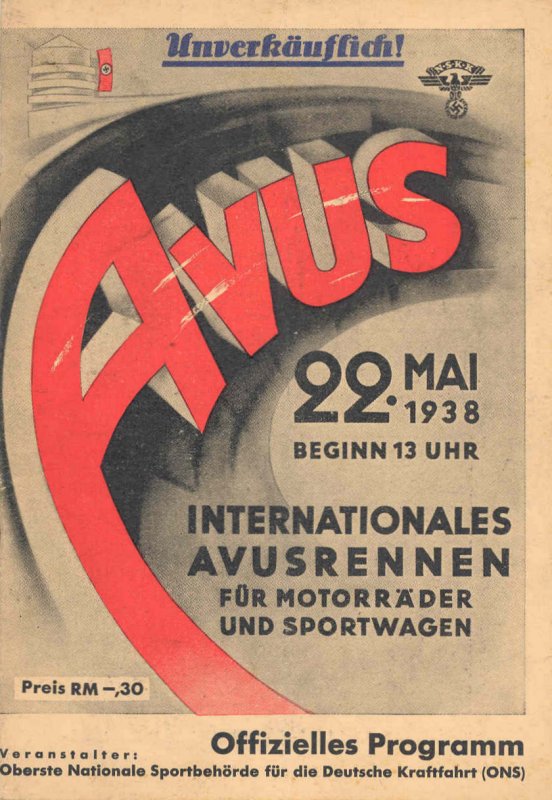
Found a copy of the programme cover for the 1938 Avusrennen on the Motor Racing Programme Covers Project website at -
http://www.progcover...otor/avus38.jpg
I note that the programme price has dropped from RM.-,50 in 1937 to RM.-.30 for the 1938, I assume because of the lesser attraction (no GP cars).
Tony
http://www.progcover...otor/avus38.jpg
I note that the programme price has dropped from RM.-,50 in 1937 to RM.-.30 for the 1938, I assume because of the lesser attraction (no GP cars).
Tony
#12
Otto Grabe
-

- 68 posts
- Joined: June 04
Member
Posted 26 December 2008 - 11:01

Originally posted by fines
East Berlin is (was!) quite some distance from where the AVUS is located, but post-WW2 the southern part of the track was in a different "sector", i.e. in the American, as opposed to the northern part in the British "sector"...;)
So it was.
Originally posted by Vitesse2 According to Kitschigin, the 1938 circuit would seem to have been the same 8.3km layout as in 1951, being described as "Steilkurve, Südkehre mit Grossen Stern".
I can't believe that this is a Kitschigin quote. The "Großer Stern" (Big Star) is situated not far of the "Brandenburger Tor" and was at no time part of the AVUS. Otherwise it would have been an "East Bend".
Otto
Sorry,there are more Big Stars in Berlin than I assumed:
Nach dem Krieg wurde eine neue Südkehre etwa auf dem halben Weg an der alten Motorradkurve kurz vor dem großen Stern an der Anschlussstelle Hüttenweg ausgebaut. Die so umgebaute AVUS-Rennstrecke hatte nun eine Länge von 8,3 km und wurde 1951 mit einem Rennen vor 350.000 Zuschauern wiedereröffnet.
Otto
#13
Nick Wa
-

- 186 posts
- Joined: June 07
Member
Posted 26 December 2008 - 14:21
Whilst driving into Berlin in March '69 going past a giant reconstruction site, I realised I had an end on view of the Nordkurve. So I can say I literally have seen the inside of the Nordkurve, I guess another week and there would have been nothing left. I was rather surprised because I thought it had already gone.
Anyway now forgive me for a bit of thread drift. How many other circuits in the area had similar bankings although on a smaller scale? I have sampled Bernau where the banking appears to have now gone but I observed at least three other curves hidden amongst the trees besides autobahn in the Berlin area. They generally seemed to be adjacent to slip roads and one was a real tight wall of death.
Note:- all of these sightings were in the old D.D.R.
#14
Hugo Boecker
-

- 702 posts
- Joined: May 04
Member
Posted 26 December 2008 - 16:24
Internationales AVUS Rennen
AVUS
22.05.38
15 laps 124,5 KM
2000 ccm class (8 started + 1 DNS + 2 DNA all BMW)
1. Kurt Illmann auf BMW 328 58:27,8
2. Heinrich v.d.Mühle-Eckart auf BMW 328 58:33,4
3. Adolf Brudes auf BMW 328 59:01
4. Otto Trittel auf BMW 328
5. Carl Anton Freiherr von Langen auf BMW 328
6. Paul Greifzu auf BMW 328
dnf H. von Walter und Croneck,
dnf Hans Holzenburg,
dns Hans Eck
DNA:
Uli Richter
fastest lap Brudes: 3:11,8;
#15
RStock
-
- 2,276 posts
- Joined: March 08
Member
Posted 26 December 2008 - 18:07
Originally posted by taylov
Thank you all for the detailed replies and on Christmas Day too !!
On the location of the hairpin South Turn, I found a clue in the 1937 Avusrennen programme. The circuit map (which is not very clear) does show what appears to be a hairpin connection a little more than a third of the way down the track. The pattern of adjacent roads seems to place it at the same location as the South Turn of 1953.
The 1938 South Turn on the film does have a slightly widened entrance and exit (compared with the rest of the straights) but is not the faster turn used in 1958 and 1959 which can be seen on the same DVD in footage of Hans Hermann's flying BRM in the 1959 German GP and which is pictured above in REDARMYSOJA's posting.
Tony
I found this bit .
The South turn was under construction in 1938 . It was demolished at Nikolassee and replaced by a junction with plans to connect it to the Reichsautobahn .
So apparently the full version couldn't be used ? Here's another quote from that 1939 copy of "The Street"
For the motorcycle race was the turning point curve at the southern big star.
I would think that indicates the 1939 hairpin was in a different location than the turn in 1951 .
I'm still trying to find the story that led me to believe the 1938 race used the same motorcycle version for the sportscars that day .
Here's a link to the 1939 story . Perhaps someone who is fluent in German can read it and find out more . The poorly translated version is a bit confusing for me .
http://members.a1.ne...istory/avus.htm
Translated version
http://translate.goo...l=e...l=en&sa=N
#16
taylov
-
- 624 posts
- Joined: February 05
Member
Posted 26 December 2008 - 18:35
Originally posted by REDARMYSOJA
I'm still trying to find the story that led me to believe the 1938 race used the same motorcycle version for the sportscars that day .
Thanks. I cannot comment on the rest of your last posting, but the film footage definitely shows both the BMW328 sportscars and the motorbikes using the same tight hairpin in 1938.
Tony
#17
Vitesse2
-
- 41,859 posts
- Joined: April 01
Administrator
Posted 26 December 2008 - 18:50
A lap length of exactly 8.3 km would work for the race distance Hugo quotes. However, that ignores the starting straight, which was a unique feature of AVUS. In 1937 it was shortened from 831 metres to 545 metres. Does the film show it being used, Tony?
#18
taylov
-
- 624 posts
- Joined: February 05
Member
Posted 26 December 2008 - 19:02
The DVD shows the start of 2 motorcycle races and the BMW 328 sportcar race. All three races start opposite the grandstand, ie after the exit of the banked North Curve. They do not use the "old start" on the special start straight.
We need the circuit map from the 1938 programme. A search on the 'net has revealed that at least 2 copies have sold at auction in the last decade. Can they have both gone to a non-TNFer?
Tony
We need the circuit map from the 1938 programme. A search on the 'net has revealed that at least 2 copies have sold at auction in the last decade. Can they have both gone to a non-TNFer?
Tony
#19
taylov
-
- 624 posts
- Joined: February 05
Member
Posted 27 December 2008 - 09:45
More internet searches over the holidays may have revealed some more information about the fate of the various Avus South Turns.
Catalina Park rightly points out in this thread that the 1950s version still partly exists alongside the motorway and can be seen on Google Earth and similar sites.
However when one searches along the motorway for remains of the 1937 South turn, nothing appears to remain. We know that it was planned to connect the southern end of the AVUS road to the autobahn network and it has been suggested that this was the real reason for the long, 1937, track not being used again.
A chance reference to the old pre-war South turn was found on a website about the US occupation of parts of Berlin in 1945. http://www.berlinbri...ans/keerans.php
This website confirms Fines' posting above that the southern part of the pre-war track ended up in the American section. It states that -
“The 82nd Airborne Division was deployed to Berlin at that time. A firing range was constructed on the "AVUS-Südkurve" (southern turn of the AVUS race-circuit) whose construction wasn't finished during the war. The small arms range was named in honor of Charles L. Keerans, Jr. who died 10-31-1945.
The Keerans range was rebuilt in the 80's and had eletronically controlled targets. These pictures were all taken in 1995. Everything was torn down later. Today there's no sign of the range left. “
Of particular interest is the third picture on the site which may just show part of the old track.
http://www.berlinbri...s/keerans_1.jpg
The derelict site can be seen on the right hand side of the motorway if one is travelling away from the startline. See http://virtualglobet...view/?service=0 It is sited just before the modern motorway begins to curve way to the left and the location is about right for the site of the 1937 South turn.
Tony
Advertisement
#20
Terry Walker
-

- 3,005 posts
- Joined: July 05
Member
Posted 27 December 2008 - 13:35
Have a look at the "G.E.R.C.A Are you a Member?" thread starting at Post 547. There's quite a bit about AVUS.
#21
eukie
-

- 247 posts
- Joined: November 03
Member
Posted 27 December 2008 - 15:23
The circuit map, published approx. 1 week before the race in the Allgemeine Automobil Zeitung.

Additional results for the motorcycle races:


Additional results for the motorcycle races:

#22
taylov
-
- 624 posts
- Joined: February 05
Member
Posted 27 December 2008 - 15:53
eukie, brilliant stuff. The motorcycle results are all new to me, except for Walfried Winkler's victory in the 350cc class which appears on the DKW website. He also won 250cc race at the Avus in 1935 and 1937.
The map in your posting is a better quality version of that which appears in the 1937 Avusrennen programme.
In comparison with the 1953 circuit map, the 1938 hairpin shown is in the same place when one looks at all of the surrounding roads.
The map in your posting is a better quality version of that which appears in the 1937 Avusrennen programme.
In comparison with the 1953 circuit map, the 1938 hairpin shown is in the same place when one looks at all of the surrounding roads.
#23
Otto Grabe
-
- 68 posts
- Joined: June 04
Member
Posted 28 December 2008 - 18:06

Drawn in yellow by my groggy hand: Position of the original South Curve. I have dug an old map (1934) out where it is pictured. Unfortunately, right now, I don’t have a scanner at hand.
http://members.a1.net/wabweb/history/avus.htm
"Die Straße" Nr. 8 vom April 1939 - A short try of translation
Carl Schnell:The AVUS is going to be a motorway of the Empire
The author reconsiders the different ways of connecting the Avus to the network of motorways.
One option was to let the South Curve untouched for further racing activities, but local conditions prevented that. An other one planned to dive under the curve but this intersection free roadway was dismissed because of some constructional difficulties and last but not least it was to expensive, so it has to be taken down. Thus no racing. But for the imperial capital, it’s prestige, the development of motorized transport and the great importance of promotional PR: this waiver was unsustainable. So i t must be a new Südschleife are involved in the project. For the location of the new South Curve the requirements of modern cars are crucial. In the past, the races on the Avus were not as popular as other races: The drivers didn’t like the very long straights and the audience wanted to see more passages of the cars in the audience space.
So the straights has to be shorten. And the new South Curve has in fact, similar to the current north curve, to be built sidelined to the actual line, in order not to obstruct to the regular traffic. The presence of the railway installations along the east side of the Avus forces to go west into Grunewald. So the elected site lies south of the so-called big star, between the Havel-Chaussee and the Fischer Hüttenweg.
The design of the new Südschleife is following new basics. The cross-section of the Avus is not adequate for races with such high speed, as usual nowadays. It is therefore necessary for the planned race track in the northern part of the Avus to widen (from 8.3 m to 10.0 m each). The new racetrack’s legths is about 14 km. Expected are lap times near three minutes by modern racing cars.
The motorcycles’ turning point was the southern curve at big star up to now. The new racetrack is short enough for the motorcycles, so that now even their race can go over the new South Curve.
(On Abb.1 you can see the whole AVUS with the planned connections as well as the new -and never finished-South Curve, location of the late firing range. The area looks bigger than the North Curve)
Otto
#24
RStock
-
- 2,276 posts
- Joined: March 08
Member
Posted 28 December 2008 - 19:39
I've been looking at the great map posted by eukie , Good Job eukie !
I'm wondering , where exactly was the "star" so frequently mentioned ?
I have an arrow pointing to a spot on eukie's map . Is that one of the "stars" ?
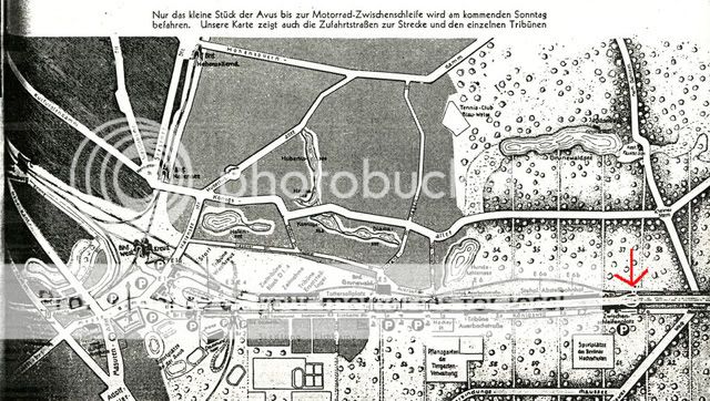
I'm wondering if that is the same turning point for the motorcycle course .
Here's a map I found at silhouette . It doesn't have a date , but looks like the turn was at the same place the arrow is pointing too in eukies map .
I'm wondering , where exactly was the "star" so frequently mentioned ?
I have an arrow pointing to a spot on eukie's map . Is that one of the "stars" ?
I'm wondering if that is the same turning point for the motorcycle course .
Here's a map I found at silhouette . It doesn't have a date , but looks like the turn was at the same place the arrow is pointing too in eukies map .
#25
Fifidad
-

- 1 posts
- Joined: December 08
New Member
Posted 28 December 2008 - 21:28
First time poster, I may have something to contribute. The link here is to a scan I made of a U.S. Army WWII map of Berlin. Dated 1944 with "photo recon updates", it is basically a 1938 German map re-printed for use by the U.S. Army (in this case the 3rd Armored Division). The scale is 1:100,000.
It looks to me that the North curve is there, but the South curve is just a "blank" spot. Guess the Army did not care about the track? There may also be a spot that indicates the turing point for the motorcycles (map box 55)?
Anyhow, I really enjoy the nostalgia forum and appreciate the effort everyone puts into it, thanks.
Link to map at Webshots.com
If the link does not work (see: first time poster above), you can go to Webshots.com and search for "Fifidad".
Edit: Just checked the link, it did not work. I'll try again.
Second try, seems to work. Click the image to enlarge.
#26
taylov
-
- 624 posts
- Joined: February 05
Member
Posted 28 December 2008 - 22:07
Originally posted by Otto Grabe
http://members.a1.net/wabweb/history/avus.htm
"Die Straße" Nr. 8 vom April 1939 - A short try of translation
Carl Schnell:The AVUS is going to be a motorway of the Empire.
Otto, thank you for posting the translation of this 1939 article.
It seems that the authorities did intend to rebuild the AVUS after the 1937 South curve was demolished for autobahn extensions and that a shorter 14km course was planned with a new large South Curve on the site of what later became the Keerans firing range.
The satellite photo suggests that the work was started but never completed.
Tony
#27
Otto Grabe
-
- 68 posts
- Joined: June 04
Member
Posted 29 December 2008 - 14:46
Originally posted by REDARMYSOJA I'm wondering , where exactly was the "star" so frequently mentioned ? I have an arrow pointing to a spot on eukie's map . Is that one of the "stars" ? I'm wondering if that is the same turning point for the motorcycle course .

Indeed, your arrow is pointing at the 1938 South Curve. The bigger circle shows the nearby five-way crossing Großer Stern (Big Star) and the smaller one encircles the small star.
OT: As I mentioned, there are still more to find. The most famous Großer Stern is situated in Berlin's Tiergarten. In the middle of the square stands the victory column with the " Goldelse " (golden sculpture of Victoria with a laurel wreath) on top.
Otto
#28
taylov
-
- 624 posts
- Joined: February 05
Member
Posted 29 December 2008 - 17:05
Originally posted by Otto Grabe
Indeed, your arrow is pointing at the 1938 South Curve. The bigger circle shows the nearby five-way crossing Großer Stern (Big Star) and the smaller one encircles the small star.
OT: As I mentioned, there are still more to find. The most famous Großer Stern is situated in Berlin's Tiergarten. In the middle of the square stands the victory column with the " Goldelse " (golden sculpture of Victoria with a laurel wreath) on top.
Otto
A "milestone" (Sorry, I don't know the correct word in german) still exists adjacent to the AVUS.
See photo at http://de.fotolia.com/id/8423897 This reads -
Nikolassee 2,7 km <
Havelchaussee 1,6 km <
Gr Stern 2.2km >
Fischerhuttenweg 0,2 km >
This should help identify the location.
Tony
#29
RStock
-
- 2,276 posts
- Joined: March 08
Member
Posted 29 December 2008 - 18:33
Originally posted by Otto Grabe
Indeed, your arrow is pointing at the 1938 South Curve. The bigger circle shows the nearby five-way crossing Großer Stern (Big Star) and the smaller one encircles the small star.
OT: As I mentioned, there are still more to find. The most famous Großer Stern is situated in Berlin's Tiergarten. In the middle of the square stands the victory column with the " Goldelse " (golden sculpture of Victoria with a laurel wreath) on top.
Otto
Thank you so much , good sir .
So , can we safely say the hairpin in Tony's original post is in the same spot as the turn used in the 59 GP ?
#30
Andy77
-

- 5 posts
- Joined: May 07
New Member
Posted 12 January 2009 - 10:01
I have quite some memories of the way to Berlin. An aunt of my grandmother lived there in Tempelhof since the 1920s and we visited her regulary during the 1980s. It was some sort of adventure to cross the former GDR on the Transit-Autobahn from Helmstedt-Marienborn to the Allied Checkpoint Bravo Berlin-Drewitz/Dreilinden.
I remember it so well because of that huge and mighty T-72 tank monument right before Checkpoint Bravo.
From Drewitz/Dreilinden to the old southern loop at Nikolassee it was just a few minutes with my dad usually commentating that "we are on the AVUS" now. As a kid back then I wondered and guessed for what the grandstands were for though. Once dad showed me - On another visit at aunties we went out to a DTM race
When I was a bit older at the end of the 80s the aunt of my grandmother told me that the old southern loop in Nikolassee was broken up to build a defensive line in the end days of world war two. And later in that place a water factory or water pump station was built until it finally became connected to the "Berliner Ring" Autobahn
Just some add
#31
speedman13
-

- 258 posts
- Joined: June 08
Member
Posted 12 January 2009 - 16:32
Do any of you AVUS experts know the whereabouts of the old podium and the new AVUS memorial.
#32
Andy77
-
- 5 posts
- Joined: May 07
New Member
Posted 12 January 2009 - 17:31
I do not know the location of the old podium.
In case of the monument, if it still is the two motorcylists, it is almost where the gate house in the 20s was. On the other side and slightly behind the Mercedes Benz house in direction to the radio tower
In case of the monument, if it still is the two motorcylists, it is almost where the gate house in the 20s was. On the other side and slightly behind the Mercedes Benz house in direction to the radio tower
#33
speedman13
-
- 258 posts
- Joined: June 08
Member
Posted 12 January 2009 - 17:40
No I do not mean the motorcycle one but a new when erected recently.
#34
wenoopy
-

- 648 posts
- Joined: January 09
Member
Posted 18 April 2009 - 11:18
I came upon this thread when looking for something else, as often happens.
There is some very useful information on Leif Snellman's website (? kolumbus.fi/leifsnellman or similar) relating to prewar racing and the Avus circuits(among many others).
He gives great detail of the track, such as dimensions, degree of banking and noting that there is a slight kink in the track, as shown on (?)eukie's map in REDARYMSOJA's note.
The holding of the 1936 Berlin Olympic Games apparently necessitated a lot of rebuilding work at the North end of the circuit, with the original Nordkurve being demolished to allow an access road for the Olympic Stadium and associated Exhibition Halls to be built. The new Nordkurve was built slightly to the south of the site of the old one, shortening the lap by 287 metres. The 1937 Formule Libre Avusrennen was run on this full 19.286 km circuit and at a record speed, but the concensus seemed to be that it was too fast, too dangerous and a boring spectacle. The death of Bernd Rosemeyer in January 1938 in a speed record attempt near Darmstadt also contributed to this unease, and the full circuit was apparently never used again.
Snellman also notes that the Sudkerve was also demolished by 1939 as the Avus was then connected to the Reichs-Autobahn system.
The "urban legend" that the full circuit was cut by the East-West Zone boundary is, of course, nonsense, as a look at a map of the Occupation Zones shows that East Germany is several kms away to the Southwest of the old Sudkerve. It would be interesting to find where this legend began. The shorter 8.3 km circuit was used at various times in the 1950's, including the non-championship Berlin Formula 1 GP of 1954, but I can find no trace of the "Soviet Zone" story until the 1959 German GP was run there. It gets a mention in "Jack Brabham's Book of Motor Racing" published 1960, and Cyril Posthumus in "The German Grand Prix" (Temple Press 1966) goes into quite some invented detail about it.
I suspect that some wit (like Dan Gurney, maybe) made a remark about the Zone boundary at the time of the 1959 GP, and was taken more seriously than he expected, and the story gained a life of its own, and is still being repeated to this day by the uninformed!
It would be interesting to know if anyone actually knows.
#35
taylov
-
- 624 posts
- Joined: February 05
Member
Posted 18 April 2009 - 11:38
Originally posted by wenoopy
The "urban legend" that the full circuit was cut by the East-West Zone boundary is, of course, nonsense, as a look at a map of the Occupation Zones shows that East Germany is several kms away to the Southwest of the old Sudkerve.
I suspect that some wit (like Dan Gurney, maybe) made a remark about the Zone boundary at the time of the 1959 GP, and was taken more seriously than he expected, and the story gained a life of its own, and is still being repeated to this day by the uninformed!
It would be interesting to know if anyone actually knows.
What!!!
You mean we can't blame Alfred Neubauer's book "Speed was my Life"

Tony
#36
fines
-
- 9,647 posts
- Joined: September 00
Member
Posted 18 April 2009 - 12:35
See my post #9, it's not an urban legend! The track was bisected by the boundary between the British and American zones - there were four occupation zones in post-war Germany, not two.;)Originally posted by wenoopy
The "urban legend" that the full circuit was cut by the East-West Zone boundary is, of course, nonsense, as a look at a map of the Occupation Zones shows that East Germany is several kms away to the Southwest of the old Sudkerve. It would be interesting to find where this legend began. The shorter 8.3 km circuit was used at various times in the 1950's, including the non-championship Berlin Formula 1 GP of 1954, but I can find no trace of the "Soviet Zone" story until the 1959 German GP was run there. It gets a mention in "Jack Brabham's Book of Motor Racing" published 1960, and Cyril Posthumus in "The German Grand Prix" (Temple Press 1966) goes into quite some invented detail about it.
I suspect that some wit (like Dan Gurney, maybe) made a remark about the Zone boundary at the time of the 1959 GP, and was taken more seriously than he expected, and the story gained a life of its own, and is still being repeated to this day by the uninformed!
It would be interesting to know if anyone actually knows.
#37
wenoopy
-
- 648 posts
- Joined: January 09
Member
Posted 19 April 2009 - 00:22
True, fines, but my recollection from information at the time was that the three Western Zones(both of Berlin and of the whole of Germany) effectively operated as a federal unit, with freedom of movement between them, whereas the Soviet Zone was very definitely a separate entity, hence the Berlin Wall, Checkpoint Charlie etc. and was definitely a "no go" zone.
The Occupation Zones were (obviously) a post WW2 creation, whereas information from Leif Snellman and elsewhere seems to make it clear that the use of the South-Western half of the circuit stopped before the war. My "legend" reference was to the claim that the Sudkerve was situated in East Germany and that this was the reason for the shortened circuit, and I think it is clear that this was not the case.
Re Taylov and the Neubauer book, if I have read this book it would have been a long time ago. Without doing too much conjecturing, assuming that you mean the Soviet zone story appears in that 1960-vintage book also, I must assume that it was at least partly ghost-written. Surely Neubauer, who was running the Mercedes F1 team only 4 or 5 years before, could not have believed it.
However, be assured that I was only trying to find more information, and re-liven the discussion.
#38
duby
-

- 191 posts
- Joined: April 04
Member
Posted 27 May 2009 - 16:12
hellow all
next month i am going to visit Berlin and one of the places i want to visit is the "old" Avus street circut .
is there any place that give a view from above the circut ?
where can i find a map with all the discriptions of the circut that i can take photos there ?
is there any motor-sport "places" in Berlin from the 34-39 era that worth a visit ?
thanks
duby
Edited by duby, 27 May 2009 - 16:13.
#39
duby
-
- 191 posts
- Joined: April 04
Member
Posted 27 May 2009 - 16:14
sorry for the add but -
is there a motor-sport book shops that you can recommend ?
thanks again
is there a motor-sport book shops that you can recommend ?
thanks again
Advertisement
#40
D-Type
-

- 9,704 posts
- Joined: February 03
Member
Posted 27 May 2009 - 16:33
Try putting "Avus" into "Search BB". I can recall seeing one thread that featured a map of Berlin to illustrate the progressive shortening of the circuit and its location straddling the British and US zones (not Russian zone or E Berlin as often stated)
#41
Ren� de Boer
-

- 402 posts
- Joined: October 02
Member
Posted 27 May 2009 - 18:07
The concrete grandstand near the start-/finishline is still there as it is a listed monument. The rest is just motorway (Autobahn A 115). When you like architecture, you will also appreciate the motorway restaurant "Rasthof Avus", which was a very modern feature in the 1930s and can be seen in many period photographs, among others on the cover of Chris Nixon's "Auto Union Album".
You might have a good view of the circuit from the nearby radio tower ("Funkturm"), but I am not quite sure whether that is actually open to the public.
As for motorsport bookshops, you probably will have a hard time finding any as they are quite rare in Germany. The only one I know of is Herbert Schneider's IMD near Cologne, which is open on Saturdays. Even general motoring bookstores have become rare, most of it is mail order nowadays, which I really regret, because I like to have a look at certain books before deciding whether to buy them or not. There was a good motoring bookstore in Munich, but it closed down a few years ago.
#42
duby
-
- 191 posts
- Joined: April 04
Member
Posted 27 May 2009 - 18:31
thanks.
where was the pits or service area located ?
duby
where was the pits or service area located ?
duby
#43
chdphd
-

- 2,801 posts
- Joined: October 03
Member
#44
Vitesse2
-
- 41,859 posts
- Joined: April 01
Administrator
Posted 27 May 2009 - 21:01
That would be this one, Duncan: Avusrennen 1938Try putting "Avus" into "Search BB". I can recall seeing one thread that featured a map of Berlin to illustrate the progressive shortening of the circuit and its location straddling the British and US zones (not Russian zone or E Berlin as often stated)
#45
duby
-
- 191 posts
- Joined: April 04
Member
Posted 08 July 2009 - 16:54
hellow again.
well in friday i suppose to arrive to Berlin.
which is the best way to go to the old circut there from the city center ? the closer to the start/finish and the concrete grandstand ?
thanks
and sorry for the many questions..
duby
well in friday i suppose to arrive to Berlin.
which is the best way to go to the old circut there from the city center ? the closer to the start/finish and the concrete grandstand ?
thanks
and sorry for the many questions..
duby
#46
dretceterini
-

- 2,991 posts
- Joined: May 02
Member
Posted 09 July 2009 - 02:00
Any photos from the sports car race. I'll assume that every car was BMW 315, 319, or 328 based...
#47
Doug Nye
-

- 11,533 posts
- Joined: February 02
Member
Posted 16 September 2009 - 21:48
I passed through Berlin last week on a military archaeology trip and took a look at AVUS for the first time, never having been there before. Several things struck me forcibly.
The first was that both the round-nosed restaurant building by the exit of the former North Wall banking, and the c. 240-metre long, narrow grandstand beside the former start area, both survive - the grandstand I understand benefiting from a preservation order....oops, as Rene mentions in his post above.
The second was that the long parallel straights are NOT in fact perfectly straight as they appear to be on most maps - there are a couple of perceptible kinks on them.
The third was that the area over which those roads run is NOT perfectly flat, as I had assumed. In fact there are a couple of perceptible brows which limit how far you can see ahead...certainly at 180mph plus.
And the fourth was how small was the area once occupied by the old high-banked North Wall.
Take a look at the place on GoogleEarth and use the ruler function to measure the diameter of the remaining North curve - it's no more than 200 metres. That really shook me. Unless, of course, the surviving traces do not reflect what was there pre-1968... but I don't see how the old banking could have followed a much wider sweep. If it really was that tight, it would of course explain the requirement for height to contain cars at such high speed.
Oh yes, the other surprise for me was that the parallel carriageways - once you get away from the relatively built-up area adjacent to the start and grandstand - are flanked by expansive acres empty of anything much other than scrub and woodland. And along the outward leg the ground falls away quite steeply amongst the trees to the right, involving a high-fly should anyone have left the road there...
The remains of the old South Curve where Hans Herrmann had his end-over-ender in the BRP-entered BRM are still evident just before the Huttenweg exit, with the slip road angling off to the right then curving back to merge with the everyday carriageway, and with a curved return layby surviving on the right-side verge of the return carriageway. Both are also visible on the GoogleEarth image. Sorry to bore you with this, just needed to note it down before I forget - which these days is in about 20 minutes...
DCN
Edited by Doug Nye, 16 September 2009 - 22:01.
#48
taylov
-
- 624 posts
- Joined: February 05
Member
Posted 17 September 2009 - 16:59
...And the fourth was how small was the area once occupied by the old high-banked North Wall.
Take a look at the place on GoogleEarth and use the ruler function to measure the diameter of the remaining North curve - it's no more than 200 metres. That really shook me. Unless, of course, the surviving traces do not reflect what was there pre-1968... but I don't see how the old banking could have followed a much wider sweep. If it really was that tight, it would of course explain the requirement for height to contain cars at such high speed.
DCN
This pre-war? shot gives a good idea of just how small a footprint the North Turn had.
Tony

#49
byrkus
-

- 1,011 posts
- Joined: October 01
Member
Posted 17 September 2009 - 17:57
Is it REALLY the North Curve...?? I'm under impression that 'underneath' North Curve there was a car park, while here is nothing but trees...
#50
Tim Murray
-

- 24,604 posts
- Joined: May 02
Moderator
Posted 17 September 2009 - 18:49
It certainly looks very different in this photo, posted by Roly in the 'AVUS 2005' thread:


