Jump to content


Photo

A Mystery Worth Exploring - the First Collie Circuit


  • Please log in to reply
6 replies to this topic

#1 Ray Bell

Ray Bell
  • Member

  • 80,248 posts
  • Joined: December 99

Posted 19 February 2015 - 00:58

To get this discussion out of the 'Personal Photos' thread, I'm starting this new one...

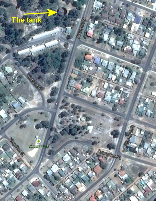
Photos provided by Ken Devine over the past week or so have forced me to conclude that Terry Walker's map of the circuit at Collie in Western Australia is just one of two such circuits. Two race meetings were held in that town and it's clear that these photos are not on that map.

Terry has stated the following:

Originally posted by Terry Walker
When I was digging around doing Fast Tracks, I tried looking up the WA Government Gazette, which was where councils would formally announce road closures for things like parades... and race meetings. I no longer have the notes handy, but for one Collie meeting there was a cluster of road closures south of the ridge where the water tank in the photos was (and still is), and the corner with the MG and Pegasus was the northernmost street closed.

However, the roads actually closed, according to the Gazette, made no sense as a circuit, since they didn't join up. My conclusion was that the circuit was entirely south of the ridge, and clockwise possibly, but where the hell it actually went was anyone's guess. There was no description or detail in Visor, nor the newspapers, such as could be found. Just that passing mention of the "white city" cicuit.

Finally I gave up as I couldn't even be sure the closed roads were necessarily part of the racing circuit, or even if the closed roads were actually used at all. There was a great deal of, er, flexibility, in arrangements, and it wasn't unknown for a road circuit to be hastily revised on the day. Hence no mention in Fast Tracks either, as I simply couldn't satisfy myself about it.

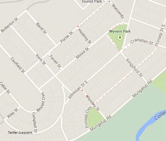
BUT, assuming the nest of closed roads WAS related to the circuit, it would have been a much shorter one that the original, and around that lower area of south Collie. And probably clockwise. From Watson St in the North to Telfer Cresc in the south, from Porter in the West to Prinsep in the East. Sort of. Maybe.


Now we have some shreds of photographic evidence that gives us some clues, I feel it's about time we did something serious about it. Hopefully, Terry will find his notes about that Gazette announcement too.

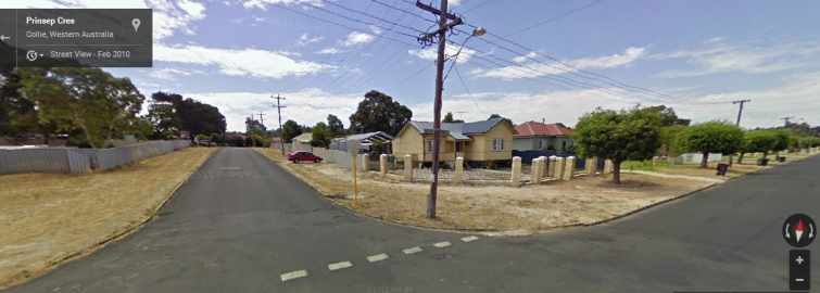
The first pic sending me off to check Google Earth was this one:

Ken003a800.jpg

And this gave a serious clue:

ken014b800.jpg

So I posted this:

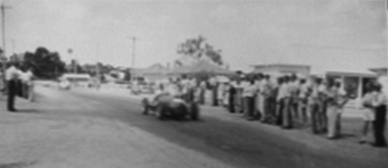
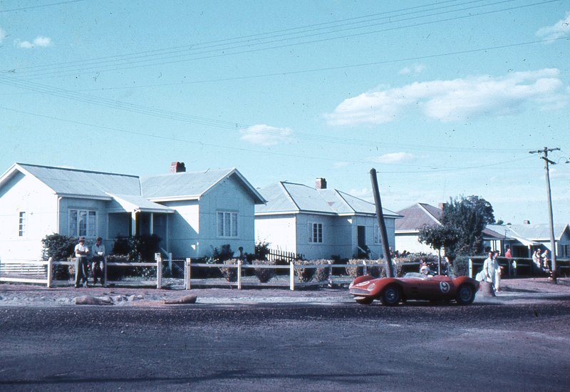
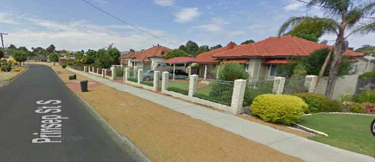
The majority of the Collie photos posted in the past week have been at this corner:

0215_GEprinsepand_Rowley.jpg

You can see, if you look at the various photos, that this is definitely where they were taken.

0215prinsepand_Rowley.jpg

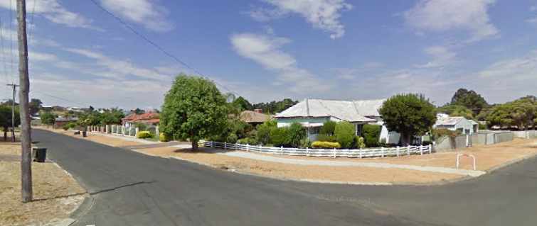
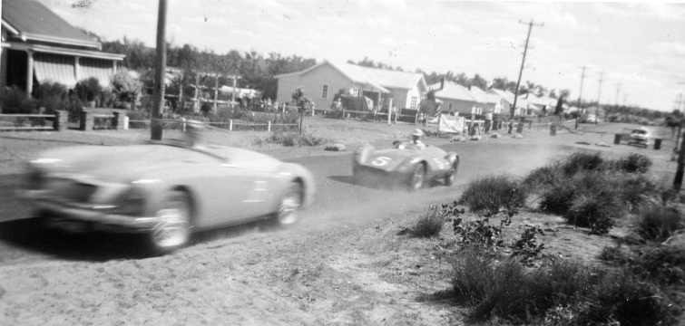
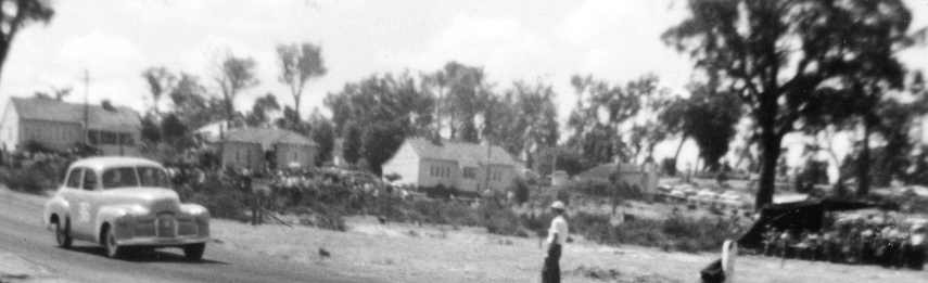
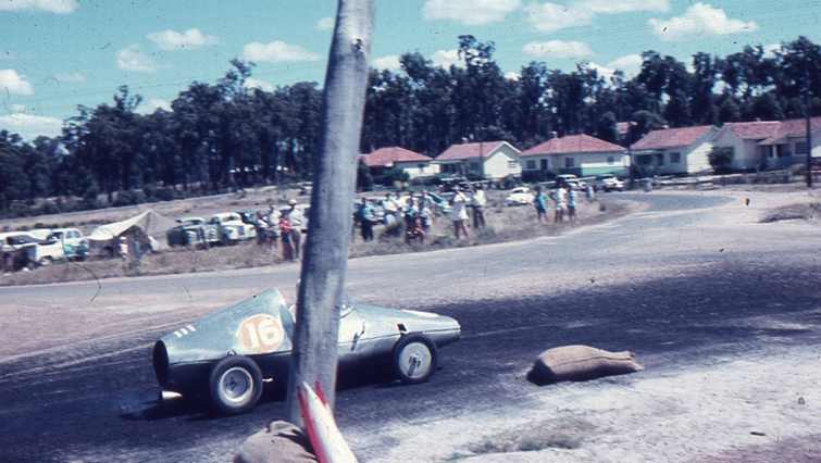
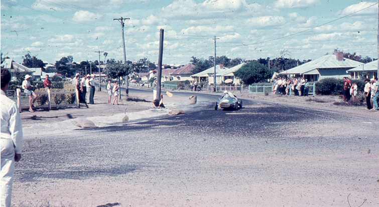
Just to further confirm this, here we have two photos from Ken clearly showing they are turning out of Prinsep Street South before it turns into Prinsep Crescent. Wally Higgs is the driver:

0215frkndvnwallyhiggsprinsep.jpg

0215frkndvnwallyhiggsturningintorowley.j

Another photo from Ken I can now confirm is in Prinsep Street South:

0215frkndvnbwrepcoholden_MG.jpg

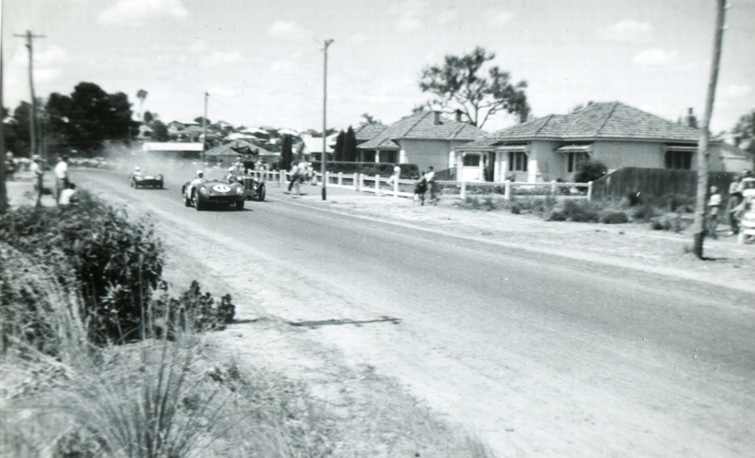
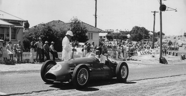
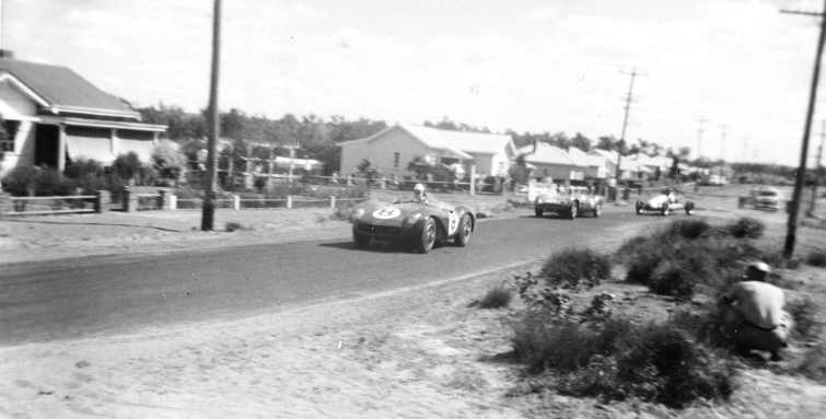
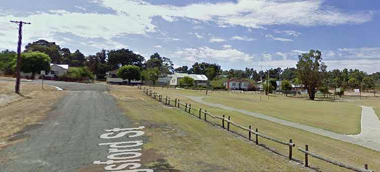
Ray Barfield in the Aston leading Bob Annear past an MG, now check the houses, this is in the block between Kingsford Street and Crampton Street...

0215prinsepststh.jpg

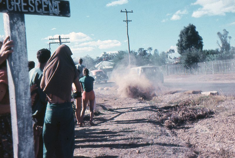
This, however, means I was wrong in an earlier post where I concluded that they had turned out of Kingsford into Prinsep Street South. Now I know how it works, check this one with Jeff Dunkerton's MG about to be swamped by Bob Annear:

0215frkndvn_Dunkerton_Annearcramptonst.j

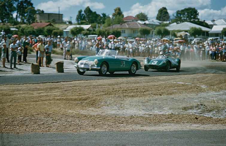
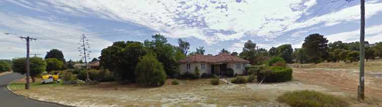
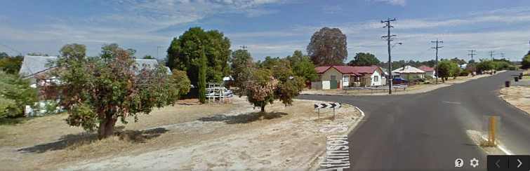
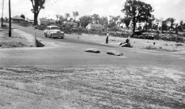
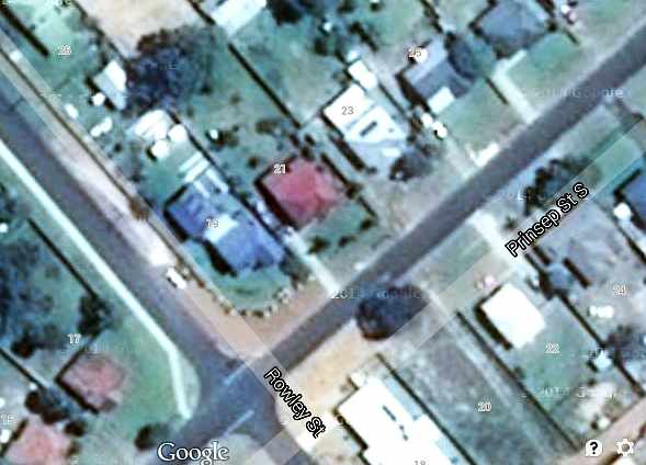
Plenty of action here, but how can I say it's at Crampton Street turning into Prinsep?

0215cramptonstreet.jpg

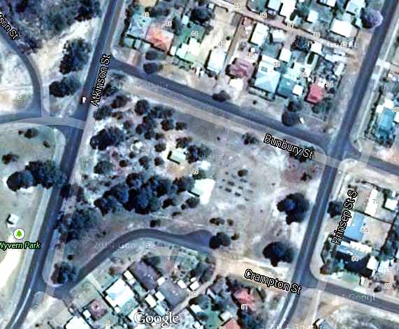
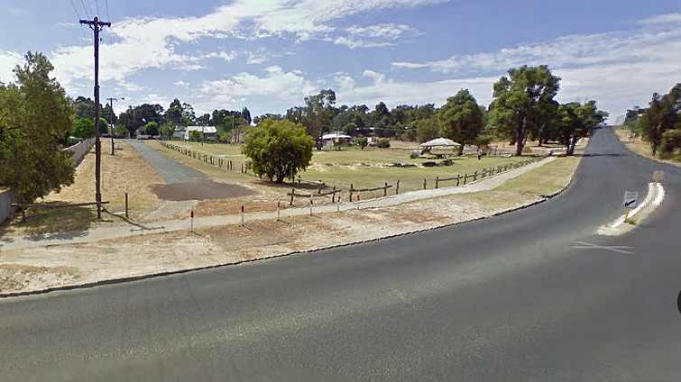
What I looked for first was that water tank on the hill. That's to the left of Atkinson Street just out of frame, trust me or ask me to post another pic. And then you see the houses across the park, check the rooflines on them and you'll see what we have.

But what of the angled bit of roadway at the bottom? Not there any more, but I don't doubt it was, just as I don't doubt that Crampton Street used to come right on through there but it has now been truncated.

Ken is sending me further pictures, though two things worry me:

1. Ken assures me that the same start/finish line was used both years. I have to work on that quite seriously. And...

2. All photos so far are from just one small part of the circuit. We need a lot more variety.

Advertisement

#2 seldo

seldo
  • Member

  • 2,601 posts
  • Joined: June 06

Posted 19 February 2015 - 02:17

Top work Sherlock! :-)

#3 Terry Walker

Terry Walker
  • Member

  • 3,005 posts
  • Joined: July 05

Posted 19 February 2015 - 04:01

Introducing the water tank:


aaacollie.jpg
forum image hosting


#4 Ray Bell

Ray Bell
  • Member

  • 80,248 posts
  • Joined: December 99

Posted 19 February 2015 - 04:47

Terry, I need some further information...

Who were the main competitors at each of these meetings? I have the placegetters, of course, but the other fast cars?

#5 Terry Walker

Terry Walker
  • Member

  • 3,005 posts
  • Joined: July 05

Posted 19 February 2015 - 05:27

The results for 1960 on my website include all the starters for each race, but unfortunately all I have on 61 is the 1,2,3 placegetters, no programme data, no starters list.  Data from this period is sketchy still.


#6 Ray Bell

Ray Bell
  • Member

  • 80,248 posts
  • Joined: December 99

Posted 19 February 2015 - 06:14

Okay, so this bloke was there in 1960?

0215altaatstart.jpg

Clearly Prinsep Street South again... and here's the house in the background:

0215housecnrcramptonandprinsep.jpg

And here's the place on the corner of Prinsep Street South and Kingsford Street, the next intersection:

0215_GEpickingsfordandprinsepsth.jpg

And this pic of Senator Sid in the Cooper Bristol is in the same place... yes, we're still in Prinsep Street South!

0215_Sid_Negus_Plymouthprinsep.jpg


.

Edited by Ray Bell, 19 February 2015 - 06:52.


#7 Ray Bell

Ray Bell
  • Member

  • 80,248 posts
  • Joined: December 99

Posted 19 February 2015 - 16:22

I've now worked out the entire Northern part of the circuit...

021560_Barfield_Ayers_Green.jpg

This picture gives us a clue as to how the competitors approached Crampton Street, from which they turned into Prinsep Street South. Note that Green in the little Cooper is turning left into this section, now where is it?

Here we have the Google street view of the junction of Kingsford and Atkinson Streets, Atkinson meeting up at an angle here and Crampton going off at this point as a 'straight ahead' run if one was coming from the South on Atkinson. Today it's very much revised, but looking at the Google Earth maps above clarify the situation.

0215_GEatkinsonandkingsford.jpg

The roof lines of the two prominent houses here are the key to the proof of the location of the racing photo, but then this one gives us some more:

021560dunkertonannearuk.jpg

I'm rather glad we can use this further rendition of Annear's chase of Dunkerton for the purpose, it looks a pretty hectic scene. But the thing we're looking at here are the two sandbags on the road where Atkinson is cut off for the racing. And there's plenty of haybales blocking off Kingsford Street too.

Then Ken has taken just one shot, it seems, from this angle looking up Kingsford Street. George Wakelin is rushing down the hill to this corner, where the sandbags on the road confirm what I've concluded:

021560wakelindownhill.jpg

And to further patch it together, we go back to Google's street view looking Kingsford (now truncated, as is Crampton) with the park to the right and those same houses at the top:

0215_GEkingsforddownhilltoatkinson.jpg

Just to see that the distinctive rooflines of the houses are, indeed the same, here's a closer look:

0215_GEkingsfordandmoorestreets.jpg

The next thing to note is where the people are standing in Wyvern Park. Just cropping the photo Ken took of Wakelin, look into the background:

0215wyvernparkcrowd.jpg

There are people lining Moore Street opposite those houses, there are plenty of cars parked up around Watson Street which Terry mentioned as being a part of the Gazetted list of closed streets. And it's Porter Street that provides the only access to Watson Street so it is also a part of the circuit.

The Visor report of February 15, 1960 reports that "The new circuit aroused much interest, but it was too tight to permit fast times..."

Even the start/finish straight in Prinsep Street South is not unduly long, it's possible that Porter Street was used for its whole length, in which case it would have been a little longer. But a look at the map will enable you to conclude that any path used to join up Rowley Street with Porter Street will hardly enhance the circuit's overall average speed.

The question remains, "Where did the rest of the circuit run?"

0215_GEcolliecircuitmap.jpg

I have marked some (somewhat rough) red dots around the part of the circuit we do know or can reasonably conclude. Terry has said that Porter Street and Telfer Crescent were mentioned ('maybe...' he actually said) in the Gazettal. I'm thinking that they ran from Rowley down Atkinson, drifted off into Telfer, possibly only as far as Campbell and then to Bessell Crescent and to Porter, possibly with a diversion up Moore Street before actually joining Porter Street.

That would be about 2.8kms. I do hope Terry can locate that Gazette notification again as it might well help straighten all of this out for us. It's ironic that all the photos we have cover such a small area, too.

It wasn't unusual, by the way, for these 'country' circuits to be well-endowed with short straights and tight corners, this serving to keep speeds down in case an incident put a car off the road at a point where spectators gathered.


.

Edited by Ray Bell, 19 February 2015 - 16:27.