Le Mans layout
#1
Posted 02 October 2003 - 12:24
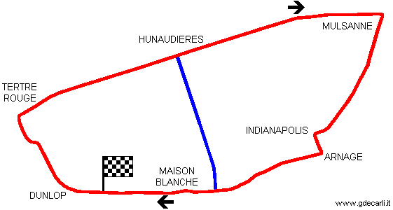
Click on the map to open my page with more details
This is layout used from 1955 to 1967; I'm sure about it because of track lenght on original map.
No problem about the traditional circuit, but what about the blue road?
I know that is the road D92 from Arnage to I-don't-remember-the-name, but why was drawn on that little card? No more roads, tribunes, pits, corners name, ... were drawn, only main circuit and this road... Why?
Was there a proposal for using it from racing or testing purpose?
Ciao,
Guido
Advertisement
#2
Posted 02 October 2003 - 17:02
I think it may be shown simply because it is the only road that remains open to serve the central part of the circuit - access is needed becuase there are farms and houses in that area who might not be too pleased to be cut off from the world completely for 24+ hours! You used to be able to get along the road, which goes under the track by a bridge at the Maison Blanche end (but is closed at the Hunadieries end IIRC).
Anyone else know anything?
#3
Posted 02 October 2003 - 21:53
This photo can give an idea of card I'm speaking about:
You can see Nürburgring (on the top) and Le Mans (bottom); I can't recognize the central one, but surely it was not so important.
Of course I draw my map by heart, not looking at this photo, as it's very hard to understand something...
I wanted to go back to buy it (only 0.50 Euro) but I didn't do for two reasons:
- I finished all my money somewhere else
- this stall was at Acque Minerali, so quite far away from pits, where I finished my lap (my record is in 2 hours and half for one lap!) and I was quite in a hurry.
For who don't know Mostra Scambio Imola, I say only that it's a big market spread on ALL Imola circuit!
Ciao,
Guido
#4
Posted 02 October 2003 - 23:34
I do recall, for instance, that during the race one could drive from the signalling pits (just after the Mulsanne corner -- where the "E" in MULSANNE is in your map) back to the main pits if one knew which of those squiggly back roads to follow.
Your blue line certainly could've represented one of those smaller roads.
#5
Posted 03 October 2003 - 20:11
Sorry it's such a mundane answer!
#6
Posted 04 October 2003 - 11:38
#7
Posted 09 October 2003 - 23:06
You mean another little bit of history has gone? - the old "straight" run from Arnage to the start/finish (OK so there is a grandstand in the way already, but even so...!)
#8
Posted 10 October 2003 - 11:27
There's also a roundabout been built at Paradis ( Rouen ), not sure when but I don't think it was there in 2002 during my last visit.
As for roundabouts at St Gaudens ( Comminges )
#9
Posted 05 September 2005 - 09:03
#10
Posted 05 September 2005 - 09:40
#11
Posted 05 September 2005 - 13:46
#12
Posted 05 September 2005 - 14:11
Thanks!
Ciao,
Guido
#14
Posted 04 May 2011 - 18:28
Was the old circuit and Pontlieue corner in the yellow or the blue indicated on the GOOGLE EARTH images?
Uploaded with ImageShack.us
#15
Posted 04 May 2011 - 19:02
#16
Posted 04 May 2011 - 19:18
I think it is the yellow line. The corner was the junction of Rue de Laignie and Avenue Georges Durand. See the picture at http://www.teamquail...ry/history1.htm (scroll down to the bottom) and compare with Google Streetview. I think the house on the right in the old picture is still there.
Thank you, I also concluded that it must be the route in yellow after looking at some old photos. Anyone else agree or disagree?
#17
Posted 04 May 2011 - 19:23
Thank you, I also concluded that it must be the route in yellow after looking at some old photos. Anyone else agree or disagree?
I agree, it's got to be the Yellow one, as it follows the Rue de Laignie directly from the circuit.
#19
Posted 04 May 2011 - 20:31
The hairpin must thus be this be place...
Uploaded with ImageShack.us
I agree since if you go back along the Rue de Laigne toward the start finish area, eventually you will find the Rue de Circuit ( 2nd road south of the ring road ( Boulevard Jean Moulin ) used to bypass the Pontlieue Hairpin in 1929 -31 before the link to Tertre Rouge came into being for the 1932 24 hours
Advertisement
#20
Posted 05 May 2011 - 00:05
I agree since if you go back along the Rue de Laigne toward the start finish area, eventually you will find the Rue de Circuit ( 2nd road south of the ring road ( Boulevard Jean Moulin ) used to bypass the Pontlieue Hairpin in 1929 -31 before the link to Tertre Rouge came into being for the 1932 24 hours
Thanks, much appreciated. Will try to get to these areas then.
#22
Posted 06 May 2011 - 15:10
Thought I'd add this picture from the 1923 race. What happened to the trees :
A wonder pic, Jager! Many thanks. The trees are gone, but the stretch down rue Georges Durand now sports a Tramline with green grass.
#23
Posted 06 May 2011 - 15:16
http://www.hells-con...20cornering.jpg
...and today with courtesy of GOOGLE EARTH:
Uploaded with ImageShack.us
#24
Posted 06 May 2011 - 17:53
Judging from the 1928 shot that Hieronymus posted, someone had already taken a saw to them by then.Thought I'd add this picture from the 1923 race. What happened to the trees :
And obviously they wouldn't want leaves on the new tram lines, so just good advanced planning by the French!