I thought I knew Sandown pretty well having watched many races there both in person and on TV
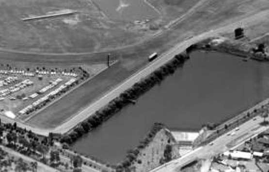
I was therefore surprised to see this 1963 photo recently posted on autopics.com.au of Frank Matich with what looks like an "inland sea" behind him.
http://autopics.com....ick-collection/
My question is what has happened to all that water?
Is it perhaps global warming?

Sandown Park Circuit
Started by
TerryS
, Feb 24 2018 23:54
24 replies to this topic
Advertisement
#2

john medley
-

- 1,442 posts
- Joined: November 02
Member
Posted 25 February 2018 - 00:03
I suspect that body of water is now hidden behind the wall out of Peters' and is the one A N Davison ventured towards in the Ford Galaxie
#3
Kenzclass
-

- 169 posts
- Joined: October 14
Member
Posted 25 February 2018 - 00:21
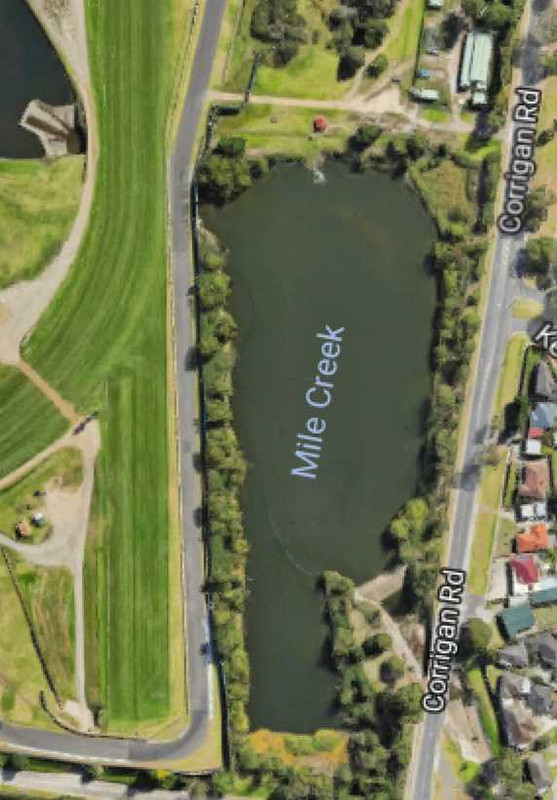
Google Earth co-ords -37.950833,145.167222 gives a great satellite pic of the course and the waterways in and around it.
Never realised the “lake” was so large.
Never realised the “lake” was so large.
#4
Lee Nicolle
-

- 11,069 posts
- Joined: July 08
Member
Posted 25 February 2018 - 01:37
As many may realise the lake is what is a semi drained swamp.
That pic would be outside of the original turn 1 which is where the sandpit is now.
A few others besides Lex found themselves in that dam! The high fence and trees disguises it well these days.
The last 2 corners on the track over the causeway is very average land , the bumps move regularly and are far worse some times than others.
Inside the horse track as well is a small lake, again draining the swamp.
Any one wanting that for housing will have to do huge remediation and even then lose about half the land area. Probably why it has not gone yet.
I suspect a good deal of the whole Springvale area is similar, I believe homes built south are suspect to moving a lot even on raft foundations.
#5
Kenzclass
-
- 169 posts
- Joined: October 14
Member
Posted 25 February 2018 - 02:50
That sort of problem didn’t stop the Emerald Lakes development on the old Surfers circuit, alas, and that may perhaps be a model for Sandown re-development.Any one wanting that for housing will have to do huge remediation and even then lose about half the land area.
Most of the development at the old SP is concentrated in area and vertically integrated” (medium rise) being built on and around the stability and elevation of the old Repco Hill, overlooking a “Lake” (read “drainage catchment area”).
Despite quite a bit of fill, the whole of the old circuit area remains an active flood plain, just waiting....
Emerald Lakes residents enjoy daily water views - always a good sales pitch.
“Extended water views” will be available when the Nerang River reaches high flood.
Edited by Kenzclass, 25 February 2018 - 02:51.
#6
Team Result
-

- 268 posts
- Joined: March 07
Member
Posted 25 February 2018 - 05:30
That sort of problem didn’t stop the Emerald Lakes development on the old Surfers circuit, alas, and that may perhaps be a model for Sandown re-development.
Most of the development at the old SP is concentrated in area and vertically integrated” (medium rise) being built on and around the stability and elevation of the old Repco Hill, overlooking a “Lake” (read “drainage catchment area”).
Despite quite a bit of fill, the whole of the old circuit area remains an active flood plain, just waiting....
Emerald Lakes residents enjoy daily water views - always a good sales pitch.
“Extended water views” will be available when the Nerang River reaches high flood.
OT Post. The 1975? 1976? Tasman round at Surfers Paradise was cancelled after torrential rains during Official Practice. It had stopped raining by Sunday morning and the actual track surface was not underwater (I did a lap or two in my racing car during the B F Goodrich party that was held at lunchtime) but the long drainage ditch was full plus!
#7
Kenzclass
-
- 169 posts
- Joined: October 14
Member
Posted 25 February 2018 - 06:17
Sorry to be go a bit OT there, TR.
The aim was to point out that, in the light of Lee’s comments re Sandown’s swampiness, developers will always find inventive ways of developing and marketing sites that really aren’t totally suitable for such development.
Mostly due to such drainage, or innundation issues.
The aim was to point out that, in the light of Lee’s comments re Sandown’s swampiness, developers will always find inventive ways of developing and marketing sites that really aren’t totally suitable for such development.
Mostly due to such drainage, or innundation issues.
#8
JohnH
-

- 172 posts
- Joined: March 03
Member
Posted 25 February 2018 - 07:21
Great topic as today - The 25th is the 50th Of Jim Clark’s final win - Tasman series Sandown. I haven’t had a chance to look further if there was another race between the next race- final round and Hockenheim a month later.
#9
Tim Murray
-

- 24,605 posts
- Joined: May 02
Moderator
Posted 25 February 2018 - 07:43
Thanks for reminding us, John. As you say, he did the last Tasman series race at Longford on 4th March, finishing fifth on uncompetitive wet tyres. His last race prior to Hockenheim was the F2 race at Barcelona on 31st March, where he retired on the first lap after being shunted from behind by Ickx. During March he had been at Indy trying out the Lotus 56 turbine car.
#10
JohnH
-
- 172 posts
- Joined: March 03
Member
Posted 25 February 2018 - 08:33
Thanks very much Tim, I haven’t had a chance to look through my Gauld book this week and it’s hard to find on these details on the net.
Edited by JohnH, 25 February 2018 - 08:40.
#11
Librules
-

- 252 posts
- Joined: September 11
Member
Posted 25 February 2018 - 08:54
Lee, I think John Medley is right re the location. It is behind what became Peter's corner (original 2nd corner) and the houses in the distance are on Corrigan Rd.
#12
Librules
-
- 252 posts
- Joined: September 11
Member
Posted 25 February 2018 - 09:23
Here's a couple of aerial shots from '69 which tend to confirm there has only ever been one body of water outside the circuit..
https://collections....u/items/2004759
https://collections....u/items/2004719
#13
Ray Bell
-

- 80,241 posts
- Joined: December 99
Member
Posted 25 February 2018 - 18:20
Those taken at a horse-race meeting with the area we know as the pics becoming part of the carpark...
Interesting.
Interesting.
#14
Ray Bell
-
- 80,241 posts
- Joined: December 99
Member
Posted 25 February 2018 - 18:52
There are good pics on P19 and P396 of the Tasman Cup book showing the extent of the water outside Peters Corner.
One is from 1969 and the other from 1972.
.
One is from 1969 and the other from 1972.
.
Edited by Ray Bell, 25 February 2018 - 18:53.
#15
TerryS
-
- 968 posts
- Joined: March 16
Member
Posted 26 February 2018 - 04:56
When one looks at these two photos plus the previous one of Matich it appears that the water is almost lapping at the edge of the track
How was there enough space then to build a wall?
http://autopics.com....ick-collection/
http://autopics.com....ick-collection/
This area is only a few hundred yards up the road from where this Torana went in, but the topography looks completely different.
http://autopics.com....er-peter-dabbs/
Were there major earthworks on the water side of the track?
#16
Lee Nicolle
-
- 11,069 posts
- Joined: July 08
Member
Posted 26 February 2018 - 05:48
Lee, I think John Medley is right re the location. It is behind what became Peter's corner (original 2nd corner) and the houses in the distance are on Corrigan Rd.
Yes. I should know,, if nothing else it is too high! And water runs down hill!! The old turn 2 I should mean. The still 90 deg corner onto the back straight.
I have never been there without all the current fences, my first time was in the 90s. And talking to the locals is how I got my knowledge. Though I grew up on a property with similar drainage issues, 72 homes now though the lowest point is a reserve.
#17
Lee Nicolle
-
- 11,069 posts
- Joined: July 08
Member
Posted 26 February 2018 - 05:52
Here's a couple of aerial shots from '69 which tend to confirm there has only ever been one body of water outside the circuit..
https://collections....u/items/2004759
The old Sandown pits had a reputation for being a bog, given the location unsurprisingly. That area is now the turn 2-3 flip flop and is another area that moves and is constantly wet off track. I have never been off there [or anywhere at Sandown] but have seen the results of those that do.
#18
Ray Bell
-
- 80,241 posts
- Joined: December 99
Member
Posted 26 February 2018 - 06:53
Originally posted by TerryS
When one looks at these two photos plus the previous one of Matich it appears that the water is almost lapping at the edge of the track
How was there enough space then to build a wall?
Simply because the water wasn't all that close!
When you look at the pic of the Negus Torana you see that there's a fair drop, and it might have been 30' or more, down to the water. The level of the track doesn't fall much (if at all) between Peters and those kink photos, and if you look at the linked aerial pic from Librules you see that the kink is virtually a bridge with a straight drop of some distance, then you understand that the water wasn't 'lapping' at the track. And it's even possible that the point at which the cars were snapped was beyond the end of the water.
A bit of an enlargement for you...
#19
Ray Bell
-
- 80,241 posts
- Joined: December 99
Member
Posted 26 February 2018 - 07:07
Terry, a further help to your understanding...
From Google Earth:
Now, if you go back to the pic of the Mini, you see there it's still on the 'bridge' and there's a low wall across that section.
From Google Earth:
Now, if you go back to the pic of the Mini, you see there it's still on the 'bridge' and there's a low wall across that section.
Advertisement
#20
Kenzclass
-
- 169 posts
- Joined: October 14
Member
Posted 26 February 2018 - 08:14
So, the thick post/bollard that appears behind each of the cars in the various photos is at the northern extremity of the bridge at the kink?
And Matich therefore has dry land to his immediate right and below track level?
And Matich therefore has dry land to his immediate right and below track level?
#21
Lee Nicolle
-
- 11,069 posts
- Joined: July 08
Member
Posted 26 February 2018 - 11:09
Just looked at Google Earth and when the pic of Sandown was taken the lake in the centre of the track is quite large. I dont remember it that large, maybe I was driving too fast as I went by!
#22
Ray Bell
-
- 80,241 posts
- Joined: December 99
Member
Posted 26 February 2018 - 13:00
I think you'll find the water level is pretty consistent, Lee...
See the dam holding back the water near Corrigan Road?
See the dam holding back the water near Corrigan Road?
#23
Lee Nicolle
-
- 11,069 posts
- Joined: July 08
Member
Posted 27 February 2018 - 09:19
It does change, meaning less banked back towards Dandenong Rd. Other pics show less.
Though as a competitor you seldom get a chance to look at it. Unless you are very slow. And I was never that.
#24
Kenzclass
-
- 169 posts
- Joined: October 14
Member
Posted 12 March 2018 - 05:55
It does change, meaning less banked back towards Dandenong Rd. Other pics show less.
Though as a competitor you seldom get a chance to look at it. Unless you are very slow. And I was never that.
I think you're right about the inner lake level fluctuating, Lee.
Looking at aerials, it seems Mile Creek fills the impoundment on the outside of the track at the top of the straight and this overflows back into the natural watercourse, but has to overtop the vertical concrete wall to fill the inner lake, whose top water level is controlled by the outlet weir at its SE corner, that Ray mentioned earlier. Don't know if there's any pumping arrangements to increase the inner lake level in prolonged dry weather.
Ditto the water level outside Peters, which is controlled its own overflow weir, also.
#25
MarkBisset
-

- 901 posts
- Joined: September 15
Member
Posted 28 April 2022 - 08:26
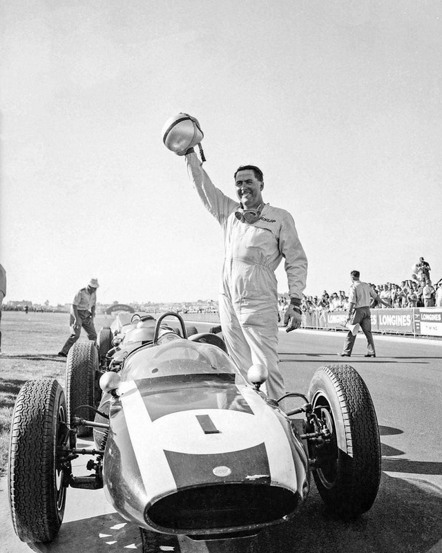
Happy Jack.
He’s just won the first Sandown International in March 1962. Cooper T55 Climax 2.7, from John Surtees and Bruce McLaren in T53 2.7s
(Clive MacKinnon)


