lads where would I find a map of the full Brands Hatch Grand Prix circuit circa 1975? It'd need it to have the relevant names in it, too. Thanking you in advance.

Map of Brands Hatch in 1975?
Started by
Gary C
, Oct 01 2018 16:07
28 replies to this topic
Advertisement
#2

Tim Murray
-

- 24,916 posts
- Joined: May 02
Moderator
Posted 01 October 2018 - 16:25
Here’s the circuit map from the programme for the 1972 1,000 km race, courtesy of the Racing Sports Cars site:

#4
Charlieman
-

- 2,591 posts
- Joined: October 09
Member
Posted 01 October 2018 - 16:55
Can anyone draw in the route taken by James Hunt in 1976, please.
#5
D-Type
-

- 9,759 posts
- Joined: February 03
Member
Posted 01 October 2018 - 19:19
I hope this helps.
lads where would I find a map of the full Brands Hatch Grand Prix circuit circa 1975? It'd need it to have the relevant names in it, too. Thanking you in advance.
According to Maurice Hamilton's British Grand Prix: "~ Pilgrim's Rise became Hailwood Hill, Bottom Bend was renamed Graham Hill Bend, Cooper Straight was the new name for Bottom Stright, South Bank Bend was changed to Surtess and the start/finish straight was renamed in honour of Jack Brabham".
Some maps show the hill from Druids down to Graham Hill Bend as 'Graham Hill'.
Mike Lang's Grand Prix says: "[ the new pits] had meant some changes to the actual track, thease having been completed in March prior to the Race of Champions. The old Bottom Straight, now re-named Cooper Straight had been moved some 40 metres into South Bank which, in turn, had made both the entry to Bottom Bend (now Graham Hill Bend) and the exit from South Bank Bend (now Surtees) far tighter." And he includes a map!
Can anyone draw in the route taken by James Hunt in 1976, please.
According to the Maurice Hamilton: "Unfortunately Regazzoni, now rolling backwards, caught the McLaren and tossed Hunt's car onto its side, the M23 tottering before crashing back onto its wheels. Hunt's relief at remaining mobile was short-lived; the collision had damaged his steering and he motored slowly up the hill, convinced he was out of the race. Then he saw the crossed 'yellow' and 'oil' flags, the sign that the race had been stopped. Now the confusion began in earnest.
. . . . Rather than attempt to drag his car round the complete lap, Hunt stopped on Cooper Straight, just behind the pits. ~"
I think some reports say that he pulled off onto the road behind the pits (ie the one just below the 'B' of Bottom Straight on the map Tim posted)
Edited by D-Type, 01 October 2018 - 19:20.
#6
Sterzo
-
- 6,363 posts
- Joined: September 11
Member
Posted 01 October 2018 - 20:17
Ah, the familiar old map of Brands from the programmes. I was never convinced the shape was quite right. From what I recall, it used to vary slightly, Bottom Bend sometimes being shown further from Druids, and Bottom Straight being, er, straighter. The Clearways loop was sometimes shown as more circular. Was Bottom Straight really that close to the start and finish straight? It's certainly quite different from the aerial photos in recent programmes, and I didn't think the Indy circuit had changed between Bottom / Graham Hill and the entry to Paddock.
Oulton Park also changed shape from programme to programme, but that's another story.
#7
Bloggsworth
-

- 9,509 posts
- Joined: April 07
Member
Posted 01 October 2018 - 20:17
Just remember, Stirling's Bend is named after the adjacent farm, not the Moss of that ilk...
#8
D-Type
-
- 9,759 posts
- Joined: February 03
Member
Posted 01 October 2018 - 20:21
Just remember, Stirling's Bend is named after the adjacent farm, not the Moss of that ilk...
Ditto for Hawthorn Bend and Hawthorn Hill.
#9
Sterzo
-
- 6,363 posts
- Joined: September 11
Member
Posted 01 October 2018 - 20:42
I think I'm right in saying there's no hawthorn at Hawthorn any more. Many trees, but haven't spotted a hawthorn. And there are certainly no pigs at Stirling's.
#10
alansart
-

- 4,420 posts
- Joined: March 07
Member
Posted 01 October 2018 - 21:09
Can anyone draw in the route taken by James Hunt in 1976, please
I think some reports say that he pulled off onto the road behind the pits (ie the one just below the 'B' of Bottom Straight on the map Tim posted)
I agree with that. I was a marshal at Bottom Bend that weekend.
#11
Collombin
-

- 9,677 posts
- Joined: March 05
Member
Posted 01 October 2018 - 21:32
Ditto for Hawthorn Bend and Hawthorn Hill.
On the extras included with the Grand Prix film DVD release, Jonathan Palmer tells us that Hawthorn Hill is named after the famous champion motorcyclist!
Edited by E.B., 01 October 2018 - 21:33.
#12
philippe7
-

- 2,862 posts
- Joined: August 03
Member
Posted 01 October 2018 - 22:20
Well, there indeed was a Maurice Hawthorne who was a british motorcycle racer of undisputable talent in the late 60's , early 70's , but I doubt his fame was sufficient to earn him the name of a curve at Brand's Hatch
Edited by philippe7, 01 October 2018 - 22:21.
#13
Tim Murray
-
- 24,916 posts
- Joined: May 02
Moderator
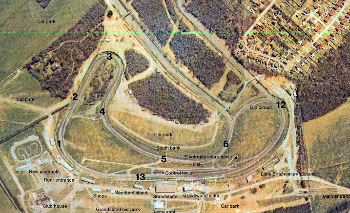
Posted 02 October 2018 - 01:36
Here’s an aerial view of the old layout, showing how close Bottom Straight did come to the start/finish straight:
#14
f1steveuk
-

- 3,589 posts
- Joined: June 04
Member
Posted 02 October 2018 - 08:55
So where is/was Derek Minter Straight on that map? It lead to Westfields, and in 1976 I am sure it was still Derek Minter Straight and had been since the late 50s!
Edited by f1steveuk, 02 October 2018 - 09:00.
#15
2F-001
-
- 4,310 posts
- Joined: November 01
Member
Posted 02 October 2018 - 09:18
And Little Britches Grandstand...? (!)
#16
Tim Murray
-
- 24,916 posts
- Joined: May 02
Moderator
Posted 02 October 2018 - 09:18
Portobello Straight was renamed Derek Minter Straight in 1976, along with all the other new names introduced after the circuit had been modified.
Derek himself had his first bike race in 1955, so would hardly have achieved enough to have a part of Brands named after him by the late ‘50s.
Derek himself had his first bike race in 1955, so would hardly have achieved enough to have a part of Brands named after him by the late ‘50s.
#17
David Lawson
-

- 984 posts
- Joined: November 03
Member
Posted 02 October 2018 - 09:24
Gary
The 1972 layout shown above isn't correct for your enquiry regarding the 1976 layout. The circuit was altered in 1975 with Paddock Hill bend tightened and Bottom Straight moved back into South Bank.
David
#18
opplock
-

- 1,035 posts
- Joined: January 10
Member
Posted 02 October 2018 - 09:36
So where is/was Derek Minter Straight on that map?
The map published in programmes still shows Derek Minter straight. It is between Hawthorns and Westfield or (in marshal speak) posts 14 and 16. Formerly known as Portobello Straight. Mind you in our briefing before the HSCC meeting 2 weeks ago one of the COC referred to Turns 1, 2 and 3. I did ask him afterwards whether he meant Paddock, Druids and Graham Hill Bend. Is nothing sacred!
#19
David Lawson
-
- 984 posts
- Joined: November 03
Member
Posted 02 October 2018 - 09:48
Gary
I have just remembered that I have the 1976 Race of Champions programme and in it is an excellent insert with a detailed map showing the circuit alterations and some nice notes by Tom Pryce describing a lap of the new layout.
If you PM me your email I will send you a pdf or if you prefer I can email Barry with it and he can forward it to you.
David
Advertisement
#20
Tim Murray
-
- 24,916 posts
- Joined: May 02
Moderator
Posted 02 October 2018 - 10:01
Gary
The 1972 layout shown above isn't correct for your enquiry regarding the 1976 layout. The circuit was altered in 1975 with Paddock Hill bend tightened and Bottom Straight moved back into South Bank.
David
Gary’s request mentioned ‘circa 1975’, ie before the circuit revisions, which were completed shortly before the 1976 Race of Champions.
#21
Geoff E
-

- 1,588 posts
- Joined: February 03
Member
Posted 02 October 2018 - 11:08
Just remember, Stirling's Bend is named after the adjacent farm, not the Moss of that ilk...
Old maps seem not to show the presence of any farm in the vicinity of the circuit.
https://maps.nls.uk/...6&right=BingHyb
#22
john winfield
-

- 5,800 posts
- Joined: July 02
Member
Posted 02 October 2018 - 12:02
Old maps seem not to show the presence of any farm in the vicinity of the circuit.
https://maps.nls.uk/...6&right=BingHyb
What a great link, thanks. No, I can't see an obvious candidate for the farm in question either, but Michael Tee makes the same Stirling/not that Stirling point in the August 1960 Motor Sport (p. 665, 'The new Brands Hatch track opens'.)
The University of Kent has a Stirling Library, named after the eminent anthropologist Paul Stirling. Perhaps he lived in West Kingsdown.....
#23
RobMk2a
-

- 264 posts
- Joined: October 14
Member
Posted 04 October 2018 - 16:06
Does anyone know when the bridge over the 'grand prix loop' was built?
Thanks
Rob
#24
Tim Murray
-
- 24,916 posts
- Joined: May 02
Moderator
Posted 04 October 2018 - 16:34
According to the August 1960 Motor Sport article referenced above by John Winfield, both the bridges along the straight after South Bank/Surtees were built as part of the 1960 track extension. There’s no mention of the bridge at the entrance to Clearways, but it must have been either already there or built at the same time as the others, as it wouldn’t have been possible to get to the others without it.
#25
john winfield
-
- 5,800 posts
- Joined: July 02
Member
Posted 04 October 2018 - 17:08
According to the August 1960 Motor Sport article referenced above by John Winfield, both the bridges along the straight after South Bank/Surtees were built as part of the 1960 track extension. There’s no mention of the bridge at the entrance to Clearways, but it must have been either already there or built at the same time as the others, as it wouldn’t have been possible to get to the others without it.
..and at some time they must have removed the Surtees bridge and rerouted traffic for South Bank parking via the Pilgrim's Drop bridge. Is that right? And that 1972 map is interesting, Tim. Did anyone ever use the car park on the infield near Hawthorns? I remember it as a wooded, muddy valley, useful as a pedestrian cut through to Dingle Dell.
The 'Surtees' bridge was still there in March 1975, but gone by July 1978.
#26
pete53
-

- 747 posts
- Joined: September 09
Member
Posted 04 October 2018 - 17:09
And Little Britches Grandstand...? (!)
As a matter of interest ( to some of us anyway) I seem to recall, a number of years back, that there was a lengthy discussion on this site on the topic of Little Britches Grandstand, and in particular, the derivation of its name. I don't think there was ever a conclusive answer.
#27
jtremlett
-

- 292 posts
- Joined: February 07
Member
Posted 04 October 2018 - 17:16
What a great link, thanks. No, I can't see an obvious candidate for the farm in question either, but Michael Tee makes the same Stirling/not that Stirling point in the August 1960 Motor Sport (p. 665, 'The new Brands Hatch track opens'.)
The University of Kent has a Stirling Library, named after the eminent anthropologist Paul Stirling. Perhaps he lived in West Kingsdown.....
Somewhere in the back of my head I thought that Stirling was the name of the farmer not the farm. I can't recall where I read that though so I might be completely wrong although I do have a booklet somewhere on the history of Brands Hatch (not sure exactly where right now...) that might have been the source.
This website http://www.racingcir...ml#.W7ZGAfZFzIU does show all the different layouts with some history (noting that Brands Hatch was itself a farm).
Interesting to note in the excellent aerial shot posted by Tim Murray above that the houses were already right up to the circuit then and nothing much seems to have changed in that regard since.
As an aside, I was devastated to find, upon visiting at the beginning of this year, that the Grand Prix loop had been enclosed with huge ugly fences, making photography near impossible, and some previously excellent vantage points now closed off altogether. I suppose one should just be thankful for having had the opportunity to have been many times when you could see the world and the racing other than through a chain link fence.
#28
Tim Murray
-
- 24,916 posts
- Joined: May 02
Moderator
Posted 04 October 2018 - 18:31
The 'Surtees' bridge was still there in March 1975, but gone by July 1978.
It went when all the rest of the circuit changes took place in 1975/76. According to the 1976 Race of Champions programme:
Safety is also the reason for the road bridge over South Bank bend being taken away and its footings, which were close to the outer edge of the track, will no longer be a race hazard.
#29
Tim Murray
-
- 24,916 posts
- Joined: May 02
Moderator
Posted 04 October 2018 - 19:22
As a matter of interest ( to some of us anyway) I seem to recall, a number of years back, that there was a lengthy discussion on this site on the topic of Little Britches Grandstand, and in particular, the derivation of its name. I don't think there was ever a conclusive answer.
Here’s the thread discussing Little Britches:
Brands Hatch 1960 spectator grandstands
As you say, Pete, no firm conclusions were reached, although the most likely suggestion was that the stand was so called as it was adjacent to the children’s play area.


