Jump to content


Photo

Bridge over the River(ina) Why?


  • Please log in to reply
9 replies to this topic

#1 Wirra

Wirra
  • Member

  • 1,326 posts
  • Joined: December 08

Posted 23 April 2019 - 23:02

Just back from a couple of weeks touring the Great Ocean Road and South Australian vineyards, plus Lobethal. Whilst travelling in the Riverina we passed under a Dunlop bridge over the highway.


What is the origin of the bridge? Was it used at a racing circuit?


a-IMAG0279-a.jpg


Advertisement

#2 Ray Bell

Ray Bell
  • Member

  • 80,217 posts
  • Joined: December 99

Posted 23 April 2019 - 23:34

So many questions!

It could actually be the Warwick Farm bridge:

http://autopics.com....lance-j-ruting/

No other circuit had a bridge which was so close to being purely the tyre profile. Geoff Sykes was adamant that the bridge not be squared off or have cutouts (like Sandown's) when they built the one over Hume Straight.

Where is it? Maybe Google has an answer?

#3 Wirra

Wirra
  • Member

  • 1,326 posts
  • Joined: December 08

Posted 23 April 2019 - 23:42

From memory, it was over the Sturt Hwy (A20)


Aren't there clever IT types who can identify the co-ordinate of photos?


(edit - found on Google) Coordinates:   34°15'36"S   140°51'41"E


More info: Been there awhile it seems. https://www.abc.net....verland/3694752


Edited by Wirra, 23 April 2019 - 23:52.


#4 Ray Bell

Ray Bell
  • Member

  • 80,217 posts
  • Joined: December 99

Posted 24 April 2019 - 03:31

Not far inside the South Australian border with Victoria and New South Wales...

At Yamba, which boasts a service station (truck stop?) and a checking station for vehicles coming from interstate. Undoubtedly a fruit fly checking station.

Found that by putting the coordinates into Google Earth.

#5 Ray Bell

Ray Bell
  • Member

  • 80,217 posts
  • Joined: December 99

Posted 24 April 2019 - 03:32

And that news item reads:

The Riverland's big tyre across the Sturt Highway could be on the skids, unless more money can be found.

It was given to South Australia by a tyre company back when the Grand Prix was in Adelaide.

For years the giant tyre has been owned and maintained by the Riverland Tourism Association.

But the Association no longer exists and Renmark Paringa Council is investigating ownership and maintenance of the Sturt Highway icon.

The council has estimated repair and upgrade costs could be about $75,000, while demolishing the tyre might cost $50,000.

It hopes sponsors and advertisers may come on board to help cover the cost of maintaining the tyre.

The owner of a nearby roadhouse, John Rolly, believes the big tyre was costly to erect and should stay.

"It was actually made by Neil Webber from Berri," he said.

"I think, off the top of my head, it was $330,000 to actually put it up and Dunlop sponsored it right up until about 2000."
Iconic

Mr Rolly thinks the landmark is distinctive.

"They've got the big lobster (at Kingston) and the big orange (in the Riverland) has had its day, but South Australia being the motoring state that it is, I believe that sort of thing should stay," he said.

Travellers on the Sturt Highway have expressed a range of views, one thinking the tyre indicated a service station and another saying it was an eyesore but worth keeping anyway.

Destination Riverland CEO Tony Sharley thinks the tyre offers opportunities for the region.

"There's probably close to one million people driving underneath it, or through it, every year and there's no doubt driving under it always makes an impression on you," he said.

"Given that, there's an opportunity to make an impression in terms of a message that could be portrayed on it."

Mr Sharley concedes a tyre might not be the best symbol to carry a Riverland message.

"I do know that Destination Riverland in its determination to really put 'brand Riverland' on the map would certainly welcome the word 'Riverland' being there on the tyre and, who knows, it may not always be a tyre," he suggested.


#6 Lee Nicolle

Lee Nicolle
  • Member

  • 11,061 posts
  • Joined: July 08

Posted 24 April 2019 - 03:47

Just back from a couple of weeks touring the Great Ocean Road and South Australian vineyards, plus Lobethal. Whilst travelling in the Riverina we passed under a Dunlop bridge over the highway.


What is the origin of the bridge? Was it used at a racing circuit?


a-IMAG0279-a.jpg

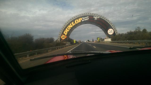
Riverland, not Riverina. From memory just as you come into Yamba  first civilisation entering SA.

It seems to be answered by others of how. Why is another thing and those usual pic a figure and multiply by 5 council estimates.


As for vineyards in SA, they seem to be popping up everywhere as they disapear elsewhere. Lobethal region has more than its share these days, Even down the SE Robe way. I have a customer who works in one down there.


Edited by Lee Nicolle, 24 April 2019 - 03:50.


#7 baz

baz
  • Member

  • 55 posts
  • Joined: December 10

Posted 24 April 2019 - 10:18

I,m just curious as to what you were driving.


#8 Ray Bell

Ray Bell
  • Member

  • 80,217 posts
  • Joined: December 99

Posted 24 April 2019 - 12:02

Or passengering in...

The same thought occurred to me.

And how did you like the circuit? Did you go to Woodside too?

#9 Wirra

Wirra
  • Member

  • 1,326 posts
  • Joined: December 08

Posted 24 April 2019 - 12:33

Same one I drove around Longford last year: https://postimg.cc/680BVBgC


The photographer (secretly call "the handbrake") always limits the velocity of travel but the roads were a bit rough anyway, Ray. There was lots of bottoming-out. Think I'll have to replace the gearbox cross-member. 


Not Woodside but did Victor Harbour.


Lovely weather but crikey it's dry over there.


#10 Ray Bell

Ray Bell
  • Member

  • 80,217 posts
  • Joined: December 99

Posted 24 April 2019 - 13:03

Ah yes, I recall that one...

And it's 'Victor Harbor', the only harbour in Australia without the 'u' in the name.

And Port Elliot lacks a second 't'.

Anyway, it sounds like you saw the sights, that's what matters. And you've got an excuse to go back.