Jump to content


Photo

G.E.R.C.A. - are you a member?


  • Please log in to reply
1043 replies to this topic

#1001 Allen Brown

Allen Brown
  • Member

  • 5,540 posts
  • Joined: December 00

Posted 12 February 2011 - 21:22

Also on the subject of Canada, I see no ... St Johns (Newfoundland) used for an Atlantic race in July 1974. All I know about St Johns is that the Montreal Gazette said that it would "take place on highways around the provincial legislature in St Johns after the pattern of Trois Rivieres". The edition of the Gazette that would have covered the race and might have given a few more clues is missing from Google's archive and I haven't yet acquired any documentation from the race.

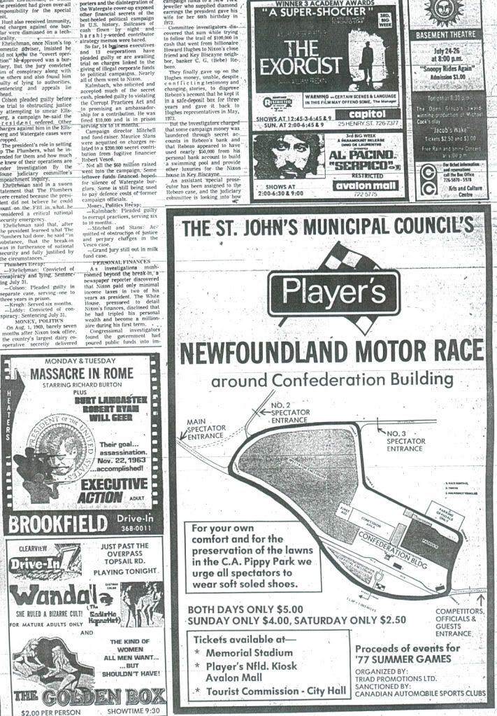
Here's a map of St Johns found by the guys on newfoundlandmotorsports.com.


Posted Image

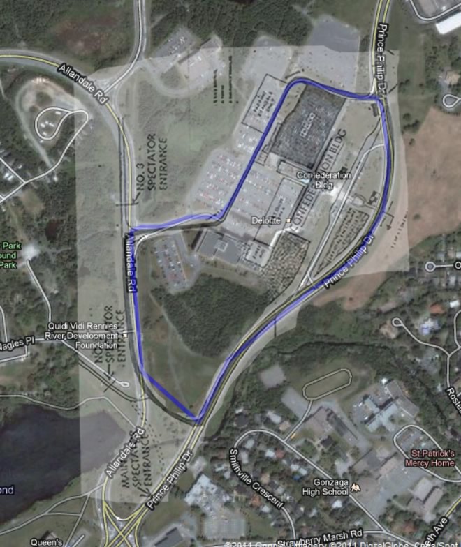
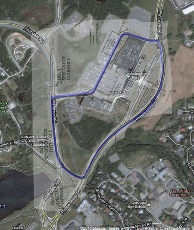
I've had a go at working out where the track was but something is wrong because there is absolutely no sign of the southernmost corner of the track on the ground. It's hard to believe that they dug up the track without leaving any trace. Maybe somebody can do a better job.

Google Map of circuit


Advertisement

#1002 Terry Walker

Terry Walker
  • Member

  • 3,005 posts
  • Joined: July 05

Posted 13 February 2011 - 02:12

There is a dark "crop mark" where I have added red dots - it's probably the line of the former roadway, and fits the circuit diagram better. And yes, total obliteration of old roads, and landscaping over them, is not unusual.

Posted Image


Edited by Terry Walker, 13 February 2011 - 02:13.


#1003 Allen Brown

Allen Brown
  • Member

  • 5,540 posts
  • Joined: December 00

Posted 13 February 2011 - 10:34

I think it's further south than that Terry. I tried superimposing the published plan on top of Google Maps and the track seems to go through where that small group of trees is now:

Posted Image

I've modified my Google Map and I think I've got it a lot closer now. Of course there's no guarantee that the published plan was accurate.

Revised version
Posted Image

Google Map

Edited by Allen Brown, 13 February 2011 - 10:41.


#1004 Terry Walker

Terry Walker
  • Member

  • 3,005 posts
  • Joined: July 05

Posted 13 February 2011 - 11:44

Yes, I see what you mean. Better fit. Modern landscaping around new roads does tend to obliterate the past very thoroughly.

#1005 Mark A

Mark A
  • Member

  • 1,173 posts
  • Joined: December 02

Posted 22 April 2011 - 17:56

Been a long time since I've been on this thread, been way too busy recently, but after mapping a couple of bike rides I've done recently I found a nifty new tool in the latest Google Earth.

If you open up my motorsport location file (in signature) and then pick a circuit, right click on the circuit 'path' and it gives an option of Show Elevation Profile. (works with any circuit path)

Here are 2 particularly hilly circuits, Charade and Nurburgring (the red dots at the ring are from my iPhone 'tracking' which I've been playing around with tonight :lol: )

Just move your pointer over the profile and it moves a red arrow around the circuit map to show the elevation at that point.


Posted Image
Posted Image

Edited by Mark A, 22 April 2011 - 17:58.


#1006 Barry Boor

Barry Boor
  • Member

  • 11,549 posts
  • Joined: October 00

Posted 18 July 2011 - 15:28

I just came across this last post from Mark. What a fascinating tool. However, I somehow doubt its accuracy because I just tried it on a circuit I know rather better than the back of my own hand - Monaco. According to G.E's elevation tool between St. Devote and the entrance to Casino Square, the circuit actually drops by 2 metres. I think that may be slightly inaccurate. The big climb, apparently, is from Casino to Mirabeau where it climbs 23 metres. Then from the Station to Portiere it climbs 9 then falls a further 12 metres. There is a large drop between Tabac and the Swimming Pool, then quite a climb up to Rascasse.

So I am wondering where they get this from? It appears to be somewhat different from the Monaco I know.

On another G.E. related matter, I wonder why I get quite a discrepancy between the path measurement of a circuit and the original stated length. I'm wondering which, if either is likely to be correct. It occurs to me to wonder if some of the older circuits were measured by people doing fairy steps and counting them, them multiplying that by the length of their shoes!

#1007 Stephen W

Stephen W
  • Member

  • 15,584 posts
  • Joined: December 04

Posted 18 July 2011 - 15:40

On another G.E. related matter, I wonder why I get quite a discrepancy between the path measurement of a circuit and the original stated length. I'm wondering which, if either is likely to be correct. It occurs to me to wonder if some of the older circuits were measured by people doing fairy steps and counting them, them multiplying that by the length of their shoes!


This is still happening today! There doesn't appear to be a standard way to measure the lap distance so some people measure all the way round on the right hand side of the track, others take their measurements from the center of the track whislt others use the racing line!

Very confusing! :confused:


#1008 David McKinney

David McKinney
  • Member

  • 14,156 posts
  • Joined: November 00

Posted 18 July 2011 - 15:51

I think the norm is to measure the middle of the road (best done by measuring the outside edge, then the inside edge, and splitting the difference)

This means that every average speed published is wrong, as few drivers stick to the middle of the road for an entire lap :lol:

#1009 arttidesco

arttidesco
  • Member

  • 6,709 posts
  • Joined: April 10

Posted 02 September 2011 - 23:15

Posted Image

My local paved oval Mendips Raceway, only found out about it on Sunday apparently it has been open since 1969, I know I am not the first TNfer to have visited the track :smoking:

#1010 Andre L M

Andre L M
  • New Member

  • 17 posts
  • Joined: December 08

Posted 01 December 2011 - 14:53

Hi

After a long time out of here, I was looking at the new posts and when I saw this one, I had some doubts that the photo could be Eureka:

- first: looking at that place with the GE "Historical Photos" tool, the oldest photo is 2000 and there is nothing in that place, as can be seen:

Posted Image

- second: if the GE measurement tool is correct, this track had less than 300 m. (!)

Some sugestions? :confused:


Last week I came across a website zambiaworldwide and made contact with several of the people i have been looking for in my previous posts on racing and rallying in Zambia and made contact with a few more useful contacts.

In the process my attention has been drawn to a 'stock car' track in Zambia I have not heard of before, thanks to Hartley Heaton I have both identified it 10 miles south of Lusaka using google earth

Posted Image

Uploaded with ImageShack.us

Eureka Speedway, Lusaka, Zambia


Posted Image

Uploaded with ImageShack.us

Eureka Speedway, Lusaka Zambia


and been pointed in the direction of a source of photographs by Hartley and David Heaton taken at Eureka Speedway in the late 60's and early 70's.

http://www.isilwana....uit/eureka.html

Note that racing at Eureka was predominantly a participant sport and spectators were free to get amazingly close to the action !

Next mission to locate the tracks in and around Garneton :-)


Edited by Andre L M, 02 December 2011 - 13:54.


#1011 Allen Brown

Allen Brown
  • Member

  • 5,540 posts
  • Joined: December 00

Posted 01 December 2011 - 15:13

Some of you may enjoy this map I put together of the tracks used for SCCA Nationals from the mid-1960s to the mid-1980s.

http://www.oldracing...om/scca/tracks/

#1012 David McKinney

David McKinney
  • Member

  • 14,156 posts
  • Joined: November 00

Posted 01 December 2011 - 17:18

Fantastic, Allen :up:

I'm surprised I haven't seen it before
(Or is my memory really getting that bad?)

#1013 Andre L M

Andre L M
  • New Member

  • 17 posts
  • Joined: December 08

Posted 01 December 2011 - 17:55

What are the coordinates?


These two tracks in Zambia have been posted else where but obviously belong here, thanks to TNFer Terry Walker who helped me locate ...


Posted Image

Uploaded with ImageShack.us

the very first race track I visited in 1970, Bennetts Speedway to the west of Ndola the road course appears to be in disrepair, but the infield now operates as Ndola Motor Sports Club for off road motor bike events.


Posted Image

Uploaded with ImageShack.us


Subsequently I have found the Lawrence Allen Circuit just north Chingola which I also visited in the early 1970's. This tarmac circuit would appear to have fallen out of use in the early 1990's last I heard the infield was being prepared for off road bike events in 2009 much like Ndola's former Bennett Speedway.


I am still hoping someone might come forward and pick out the street circuit used for events in the late 1950's in Garneton, also on the Copperbelt and possibly scene of the first races held on tarmac in Zambia.

11/06/10 Correction Edit The top track here currently known as Ndola Motopark was never known as Bennett's Speedway which it turns out was somewhere near what is now Luangwa Township in Kitwe.


#1014 Allen Brown

Allen Brown
  • Member

  • 5,540 posts
  • Joined: December 00

Posted 01 December 2011 - 18:14

Fantastic, Allen :up:

I'm surprised I haven't seen it before
(Or is my memory really getting that bad?)

You have seen it before, but it has a lot more tracks on it than it did.

#1015 David McKinney

David McKinney
  • Member

  • 14,156 posts
  • Joined: November 00

Posted 01 December 2011 - 20:27

Perhaps that's the explanation ;)

#1016 Terry Walker

Terry Walker
  • Member

  • 3,005 posts
  • Joined: July 05

Posted 02 December 2011 - 04:32

Prowling a local airphoto site, I had to see how close-up I could get to some of Western Australian circuits, present and defunct.

These are full scale screen dumps, cropped to 1000 x 700 but not reduced.

Busselton Airstrip, a Tee-circuit last used in the early 60s. This chunk shows just the short leg of the Tee.

Posted Image

Mooliabeenie, last used in the mid 1950s. This shows a section of the esses around the back. I walked this circuit a few years ago, and the tiny little bush flies were as affectionate and adhesive as ever. The gravel patch off to one side is an old dispersals bay for parking aircraft. It was wbuilt in WW2 as a satellite airstrip to Pearce.

Posted Image

Barbagallo Raceway, the junction to the short circuit, which runs downwards. The wide stretch on the right is the former pit apron and paddock area.

Posted Image


#1017 LittleChris

LittleChris
  • Member

  • 3,729 posts
  • Joined: April 01

Posted 01 March 2012 - 23:35

I think this may be the circuit used in 2005 for the one off Ballybunion road race meeting which saw the sad death of Richard Britton. There is a memorial plaque to him situated where the picture is marked X.

Posted Image


#1018 LittleChris

LittleChris
  • Member

  • 3,729 posts
  • Joined: April 01

Posted 18 May 2012 - 21:45

The circuit at Senigallia last used during the 50's

Posted Image

Uploaded with ImageShack.us

#1019 LittleChris

LittleChris
  • Member

  • 3,729 posts
  • Joined: April 01

Posted 18 May 2012 - 22:07

The old Falkenberg used from 1952 - 1965 then replaced with the current autodrome

Posted Image

Uploaded with ImageShack.us

Advertisement

#1020 wolf sun

wolf sun
  • Member

  • 842 posts
  • Joined: September 05

Posted 19 November 2014 - 14:37

For the circuit geeks out there - this site offers downloadable aerial photography of just about everywhere in France from 1919 to the present day:


http://www.geoportail.gouv.fr/accueil  


Invaluable, really - found such gems as construction work of the first 'new' Tertre Rouge in 1978, Le Castellet and Dijon as they were being built, etc.


Have fun! :wave:


#1021 Catalina Park

Catalina Park
  • Member

  • 6,777 posts
  • Joined: July 01

Posted 23 November 2014 - 09:36

For the circuit geeks out there - this site offers downloadable aerial photography of just about everywhere in France from 1919 to the present day:
 
http://www.geoportail.gouv.fr/accueil  
 
Invaluable, really - found such gems as construction work of the first 'new' Tertre Rouge in 1978, Le Castellet and Dijon as they were being built, etc.
 
Have fun! :wave:

I had a bit of a play and got nowhere, I think my lack of French is hurting me.
I could't find how to get historic views.

#1022 wolf sun

wolf sun
  • Member

  • 842 posts
  • Joined: September 05

Posted 23 November 2014 - 16:32

Hi Catalina,


my bad, I should have given a quick tutorial.


1. Open the link I provided, and type in a location as you would in G**gle Maps, press enter or click "y aller"

2. Click "Remonter le temps", then, on the dropdown menu that has now opened - "Que souhaitez-vous consulter?" - choose "Les prises des vues aériennes"

3. You might then be prompted to zoom to the appropriate scale, so do that

4. You should then see a timeline - clicking on the year you want to see should give you crosshairs on the map - hovering over one will give you the size/scope of the photography

5. Click on the crosshairs of your choice, then choose to either preview (apercu), download (télécharger), or buy (acheter) the picture.


Hope that helps.


#1023 Catalina Park

Catalina Park
  • Member

  • 6,777 posts
  • Joined: July 01

Posted 24 November 2014 - 05:44

That helps a lot! Thank you very much.

#1024 Catalina Park

Catalina Park
  • Member

  • 6,777 posts
  • Joined: July 01

Posted 26 November 2014 - 11:04

Thanks again Wolfgang.
I was just looking at Albi, I can see the grandstand getting built and then I can see it getting demolished!

#1025 LittleChris

LittleChris
  • Member

  • 3,729 posts
  • Joined: April 01

Posted 26 November 2014 - 22:01

In Rouen 1970 you can see where the old Paradis curve is in relation to the bridge that now crosses the autoroute and in 1972 the freshly laid tarmac of the new link


#1026 wolf sun

wolf sun
  • Member

  • 842 posts
  • Joined: September 05

Posted 27 November 2014 - 15:21

It's brilliant, isn't it?

I wish such a thing existed for other countries as well...


#1027 alansart

alansart
  • Member

  • 4,420 posts
  • Joined: March 07

Posted 28 November 2014 - 08:33

It's brilliant, isn't it?

I wish such a thing existed for other countries as well...

There is the Historical Imagery Facility on Google Earth which covers parts of the UK mainly the South East. It's mainly WWII but you can see some development of Brands Hatch and Lydden Hill plus there's wartime views of Oulton Park, Silverstone and Crystal Palace. No doubt there's other circuits there which have come and gone.


#1028 LittleChris

LittleChris
  • Member

  • 3,729 posts
  • Joined: April 01

Posted 28 November 2014 - 23:54

One for Barry, just found the 1952 Amiens circuit exactly where we all eventually worked out it was probably located :up: 


#1029 LittleChris

LittleChris
  • Member

  • 3,729 posts
  • Joined: April 01

Posted 29 November 2014 - 00:09

Just looking at Caen 1956 and it looks like it may have had a pit lane seperated from the track which surely would;'ve been pretty rare then ?


#1030 wolf sun

wolf sun
  • Member

  • 842 posts
  • Joined: September 05

Posted 29 November 2014 - 00:52

Thanks for the hint, Alan, it's most appreciated!


LittleChris, looks like we're circuit-geekery soulmates, very reassuring - in fact, I'd love to do a Francorchamps trackwalk with you (the proper track, naturally)! :wave:


Edited by wolf sun, 29 November 2014 - 00:53.


#1031 wolf sun

wolf sun
  • Member

  • 842 posts
  • Joined: September 05

Posted 29 November 2014 - 00:52

Just looking at Caen 1956 and it looks like it may have had a pit lane seperated from the track which surely would;'ve been pretty rare then ?

It does doesn't it!


#1032 Catalina Park

Catalina Park
  • Member

  • 6,777 posts
  • Joined: July 01

Posted 29 November 2014 - 04:25

I've been looking at Charade. Surprising to see how they just added a couple of bits to the existing roads to make it into a circuit.

#1033 Catalina Park

Catalina Park
  • Member

  • 6,777 posts
  • Joined: July 01

Posted 29 November 2014 - 04:48

Caen in 1946/47 is tough.

#1034 Barry Boor

Barry Boor
  • Member

  • 11,549 posts
  • Joined: October 00

Posted 29 November 2014 - 07:35

I have just looked at this website on my I-pad but it does not allow me to type in a location, or specify a date.

I'll try on my laptop later and hope for more success.

#1035 alansart

alansart
  • Member

  • 4,420 posts
  • Joined: March 07

Posted 29 November 2014 - 10:47

Not sure if 'Britain from Above' has been mentioned before but this is Silverstone in the late 40's and early 50's.

http://www.britainfr...rch=Silverstone


#1036 LittleChris

LittleChris
  • Member

  • 3,729 posts
  • Joined: April 01

Posted 29 November 2014 - 11:13

Thanks for the hint, Alan, it's most appreciated!


LittleChris, looks like we're circuit-geekery soulmates, very reassuring - in fact, I'd love to do a Francorchamps trackwalk with you (the proper track, naturally)! :wave:

Sounds good to me wolf sun . I think there'd be quite a few others on this thread joining us :clap:


#1037 wolf sun

wolf sun
  • Member

  • 842 posts
  • Joined: September 05

Posted 01 December 2014 - 12:21

No objections at all to that Chris! Gathering knowledge and enthusiasm can only be a good thing. :wave:


#1038 Mark A

Mark A
  • Member

  • 1,173 posts
  • Joined: December 02

Posted 01 December 2014 - 12:27

Been a very long time since I looked at this thread or played around with my GE circuits file.


Now I actually have some spare time again, I think I;ll start having a look at stuff again, especially with the French site mentioned above.


#1039 byrkus

byrkus
  • Member

  • 1,011 posts
  • Joined: October 01

Posted 07 December 2014 - 21:16

On that french site, Monte Carlo is also available to see. Not quite by search button, but you can still search for Nice or Cannes, and than move along the shore for a while. It's quite amazing, how little the track changed throught ime - and also, how quick several new buildings were put up...


Advertisement

#1040 Michael Ferner

Michael Ferner
  • Member

  • 7,203 posts
  • Joined: November 09

Posted 07 December 2014 - 22:10

I don't think walking Francorchamps is that good an idea. Last time I went around with a car (granted, several years ago), the traffic wasn't very dense, but I didn't fancy stopping anywhere because cars were travelling quite fast, and visibility is not great around the bends. Walking around that track in everyday traffic is probably more lethal than driving around in an F1 car!


#1041 Michael Ferner

Michael Ferner
  • Member

  • 7,203 posts
  • Joined: November 09

Posted 07 September 2019 - 22:19

Today I made a bike tour around parts of the old Cascais street circuit, a lovely seaside resort in Portugal. I only rode the part of the old track running along the Avenida Rei Humberto II de Itália, with a stunning view of the Atlantic Ocean from high above a cliffed coast line. Knowing the conditions of racing in the sixties, I just shudder at the thought of a car leaving the track and facing a 50 feet drop into the ocean - if you're lucky, that is; if not, you'll drop the same distance onto a mass of rock face, artistically formed by centuries of tidal waves. :eek:


Still, a lovely place. :cool: Oh, and if you happen to be there, just continue on the N247 westwards for a couple kilometres, and stop at the Restaurante Furnas do Guincho - you'll get sensational seafood for a reasonable price, in a splendid atmosphere! :love:


#1042 LittleChris

LittleChris
  • Member

  • 3,729 posts
  • Joined: April 01

Posted 08 September 2019 - 19:58

Would love to visit Cascais, Michael, looks like a proper track.  From memory Jurg Dubler's F3 book mentions that they changed the track slightly one year but didn't mention the change to the drivers before they went out to practice.   The change ?  They'd built a roundabout, with fountain in the middle, halfway down the main straight …….


I assume these were the days before everyone walked round the track the night before practice examining every kerb and minute change in track surface  :drunk:


#1043 Terry Walker

Terry Walker
  • Member

  • 3,005 posts
  • Joined: July 05

Posted 11 September 2019 - 01:27

A few years ago I visited the Collie Motorplex, a 1-mile circuit built on site roads on a former coal mine in Collie Western Australia. There was talk then about lengthening it to 1.5 miles. Well, after visiting this thread a few minutes ago I toddled off to Google Earth and found that it has been done. The new section required construction of a very short link, and resurfacing of existing roads.


colliemotorplex.jpg


#1044 wolf sun

wolf sun
  • Member

  • 842 posts
  • Joined: September 05

Posted 21 October 2019 - 09:56

Nivelles in 1971:

https://geoportail.w...9#CTX=default_t