My annual trip to the Six Hours is coming up as well

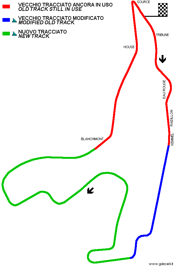
- I´ve visited Spa more or less regularly during the last ten years or so, and usually I drive a couple of times from Les Combes to Blanchimont (and back). It always strikes me how much changes from year to year, while at the same time many things still look almost exactly like they did in period.
I did take quite a few pictures of the old circuit two or three years ago, but my scanner´s not working at the moment, so I can´t post them. I´ve gone digital this year, though, so I will probably do another photo tour in late September.
A few things of note:
The road from Stavelot up to Blanchimont ("the spooky section") has been completely resurfaced, in 2004 I think. Before that, the tarmac was in incredibly bad condition, but rather more 'historically relevant', I suppose...
I think the biggest error in the GPL track is that they have modelled the section after Kemmel as per the new circuit ie straight all the way up the hill to Les Combes/Haut de la Cote, whereas during the days of the old circuit, this featured several very fast curves as the hill was ascended.
Apparently so, yes, as everybody who´d been there back in the days points this out - I´d love to see old overhead shots of that section. I´ve only ever seen trackside views, so I´ve no idea where exactly these curves were located.
traffic coming towards Malmedy from the Masta kink could use the old road for the first 1/4 mile or so of the straight.
I´ve never been sure if this is really the old road. There´s another thread, where two pictures - from the seventies and the noughties, respectively - are compared, which seem to suggest that the whole area around that junction has been altered. I will see if I can find it later.

 Id love to a do a track trip round europe and this would definately be on high on my list as its not too far from the old nurburgring which is priority no1 for me. Just have to make sure I dont cut any corners...


 is that the other kink was located at the marshals` post after that same footbridge. If you look at Google Maps you´ll notice a tiny strip of tarmac blending into a grassy track to the right of the circuit. I might however be completely wrong...


