Jump to content


Photo

Starkey's Bridge


  • Please log in to reply
107 replies to this topic

#1 Porsche718

Porsche718
  • Member

  • 865 posts
  • Joined: August 16

Posted 17 April 2018 - 07:17

Hi guys, 


Just been updating my pre-war Donington Park race results and started thinking about "Starkey's Bridge"


What was the history of it? Apart from some sites mentioning it now being Heritage Listed and protected, why was it built? I seen suggestions that it was purely ornamental. But did it serve a purpose?


Await info from you Northern Hemisphere-ites.


Cheers, Steve


Advertisement

#2 Geoff E

Geoff E
  • Member

  • 1,531 posts
  • Joined: February 03

Posted 17 April 2018 - 07:40

Although it seems to have carried a public footpath, I guess it was largely ornamental.

Map http://maps.nls.uk/g...6&right=BingHyb

#3 Tim Murray

Tim Murray
  • Moderator

  • 24,607 posts
  • Joined: May 02

Posted 17 April 2018 - 07:50

According to this site it was built as a ‘garden feature’ and is dated 1834:

https://historicengl...t-entry/1101518

The name Starkey crops up often at Donington; the old map in Geoff’s link shows a Starkey’s Pond (where the Old Hairpin is now)
and a Starkey’s Hill, and there was a Starkey’s Corner on the original circuit. Who was this Starkey?

#4 Porsche718

Porsche718
  • Member

  • 865 posts
  • Joined: August 16

Posted 17 April 2018 - 08:04

Geoff, I noticed that in the "modern" map on that link, it shows an extension from Starkey's Bridge that continued over the new track. I wonder why that was built and what the plan was.


It was there in 2012....


Donington2012.png


but not there in 2015,,,


Donington2015.png


All extremely interesting.


PS: I am not a bike nut (I want to live for a while longer  ;) ), it's just the only footage I could find that illustrated my point!


#5 Vitesse2

Vitesse2
  • Administrator

  • 41,869 posts
  • Joined: April 01

Posted 17 April 2018 - 08:05

The English Heritage listing calls it a 'garden feature', built in 1834. The house itself dates to the 1790s.


Bridge, built as a garden feature. Dated 1834 on tablet over central arch on north west side. Ashlar, slightly rusticated. 3 semi-circular arches on piers with full-height cut waters to both sides. Coped parapet with moulded string. At north east end walls curve out to battered piers, with retaining wall contin- uing for short distance beyond pier on north side. Bridge terminates abruptly to south west at edge of Donington Park race track.

https://historicengl...t-entry/1101518


The legacy source mentioned (LBS) doesn't seem to be explained but I'd guess at something like 'Leicestershire Buildings Survey'.


Maybe get in touch with the people at Castle Donington Museum? They might know more.


http://www.castledoningtonmuseum.org/


Between the wars the house and park were open as a tourist attraction and hosted all sorts of events, including meetings of the Quorn Hunt. Attractions offered included hotel accommodation, restaurants, boat trips, fishing, tennis courts, putting greens and the escape tunnel built by German PoWs during the Great War; the Hall was an officers' PoW camp during both World Wars and seems to have been the inspiration for Hadleigh Hall, Derbyshire, the fictional officers' camp in The Life and Death of Colonel Blimp.


#6 Porsche718

Porsche718
  • Member

  • 865 posts
  • Joined: August 16

Posted 17 April 2018 - 08:11

So in regard to Geoff's "older" map, I was going to ask about Kennel House but I'm thinking it may be fairly obvious. Kennels for the hounting dogs?


And what about Coppice Lodge? Also gone?


#7 Porsche718

Porsche718
  • Member

  • 865 posts
  • Joined: August 16

Posted 17 April 2018 - 08:24

A quick quiz.


What do we older types, who possess a passion for years gone by prefer. 


This.....

Donington_MG.png


or this....


Donington_Now.png


Bet you can't guess which I prefer!


Edit: I also note in the photo with Eddie Hall, a separate stone column by itself. Perhaps that was a monument to our friend Starkey? Is it still there?


Edited by Porsche718, 17 April 2018 - 08:26.


#8 Vitesse2

Vitesse2
  • Administrator

  • 41,869 posts
  • Joined: April 01

Posted 17 April 2018 - 08:39

According to this, the kennels were indeed for the Quorn - built in about 1835, now demolished. See page 10:


https://www.le.ac.uk...r - Squires.pdf


No clue on who Starkey was, although I did find a maltster of that name in Kegworth in an 1828 trade directory!


#9 Vitesse2

Vitesse2
  • Administrator

  • 41,869 posts
  • Joined: April 01

Posted 17 April 2018 - 08:43

There is also a booklet called 'Donington hall and park: an illustrated history', published by Castle Donington Local History Society in 1991. Seems quite rare - only copy I can find is in Leicester Central Library, although I guess the Castle Donington Museum will have one too.


#10 Porsche718

Porsche718
  • Member

  • 865 posts
  • Joined: August 16

Posted 17 April 2018 - 09:06

Vitesse, from that article - I love this....


Donington_Article.png


I hope the beheading part doesn't come back into fashion! But just in case I've told the wife to go and pay the council rates TOMORROW!!


#11 Vitesse2

Vitesse2
  • Administrator

  • 41,869 posts
  • Joined: April 01

Posted 17 April 2018 - 10:10

I suspect that as traitors their ends were slightly more complicated than just having their heads lopped off. As this explains:


Medieval Execution Methods - Decapitation
Prisoners were sentenced to having their head struck off their body. The axe was used for this purpose which resulted in the head often being roughly hacked off the victim, requiring several blows. When clemency was granted a sword was used which removed the head by one swift cut.

Medieval Execution Methods - Hung, drawn and quartered
One of the most terrible methods of execution ever invented and used extensively in England as the punishment for traitors. The condemned was hanged till they were half dead, and then taken down, and quartered alive. After that, their members and bowels were cut from their bodies, and thrown into a fire, while they were still alive. They would finally be killed by decapitation.

http://www.medieval-...ion-methods.htm


Or as '1066 and All That' puts it - 'hanged, drawn and quartered and then allowed to flee the country.'  ;)


#12 john winfield

john winfield
  • Member

  • 5,668 posts
  • Joined: July 02

Posted 17 April 2018 - 10:56

A quick quiz.


What do we older types, who possess a passion for years gone by prefer. 


This.....

Donington_MG.png


or this....


Donington_Now.png


Bet you can't guess which I prefer!


Edit: I also note in the photo with Eddie Hall, a separate stone column by itself. Perhaps that was a monument to our friend Starkey? Is it still there?


Yes, such a sad contrast. Although Donington is my nearest circuit, I had begun some years ago to dislike the increasing bleakness of the place. I think the lower shot shows the infield still recovering from the excavations linked to the recent abortive Grand Prix bid. But even with many of the trees gone, the grassy infield was still a pleasant place for spectators - I haven't been for a while so don't know what state it's in now.

I explored the circuit a little in 1974, was driven round the unfinished track in 1976, and watched racing there in 1977 and 1979.  There were far more trees around then than now, but sadly no-one raced under the bridge. Intentionally anyway.


#13 Charlieman

Charlieman
  • Member

  • 2,545 posts
  • Joined: October 09

Posted 17 April 2018 - 11:38

I hoped that the Britain from Above site would have some old photos of Donington Park, but alas. Well worth a visit, though, for some stunning photos of Brooklands.


https://britainfromabove.org.uk/


#14 Porsche718

Porsche718
  • Member

  • 865 posts
  • Joined: August 16

Posted 17 April 2018 - 11:57

Found this...


Sadly no footage of these monsters racing under the Bridge.


At 1:39 it shows the cars racing between the farm houses. When did the "no passing" rule (which was in place for the first meetings) get abolished?


#15 2F-001

2F-001
  • Member

  • 4,245 posts
  • Joined: November 01

Posted 17 April 2018 - 13:36

The voice-over said that was the last Grand Prix at Donington for thirty years. Did I miss something?


Edited by 2F-001, 17 April 2018 - 13:36.


#16 alansart

alansart
  • Member

  • 4,420 posts
  • Joined: March 07

Posted 17 April 2018 - 17:47

The voice-over said that was the last Grand Prix at Donington for thirty years. Did I miss something?

Possibly produced before big Tom got his GP?


#17 E1pix

E1pix
  • Member

  • 23,469 posts
  • Joined: January 11

Posted 17 April 2018 - 18:06

I suspect that as traitors their ends were slightly more complicated than just having their heads lopped off. As this explains:

http://www.medieval-...ion-methods.htm
 
Or as '1066 and All That' puts it - 'hanged, drawn and quartered and then allowed to flee the country.'  ;)

Thankful I was never caught during my traitor phase...

#18 D28

D28
  • Member

  • 2,028 posts
  • Joined: April 14

Posted 17 April 2018 - 19:19

Found this...


Sadly no footage of these monsters racing under the Bridge.


At 1:39 it shows the cars racing between the farm houses. When did the "no passing" rule (which was in place for the first meetings) get abolished?

Great footage, thanks for posting this.  It also misses the much discussed and eloquently described antics of Nuvolari upon arriving at the pool of dropped oil. Forced onto the grass, but not fighting the car unduly, he let it more or less take its own course back onto the track. This account comes from William Court Power And Glory but there are others; I seem to recall Rob Walker writing of this incident and I believe he was present that day. 


Edited by D28, 17 April 2018 - 19:20.


#19 PayasYouRace

PayasYouRace
  • Racing Sims Forum Host

  • 46,555 posts
  • Joined: January 10

Posted 17 April 2018 - 19:37

If I had a time machine I’d travel between the world’s Grands Prix of the early years, convincing the quickest drivers to mount a GoPro to their cars for a quick flying lap of all the classic circuits.

Thanks for that side by side map site. It’s incredible to see how closely the track follows the original lanes.

Regarding names, why is the Old Hairpin called that when it was evidently never a hairpin?

Advertisement

#20 Vitesse2

Vitesse2
  • Administrator

  • 41,869 posts
  • Joined: April 01

Posted 17 April 2018 - 20:21

It was always called the Hairpin, going right back to the 1931 layout. No idea why!


http://www.silhouet....s/doningto.html


#21 Doug Nye

Doug Nye
  • Member

  • 11,535 posts
  • Joined: February 02

Posted 17 April 2018 - 20:38

I first really became aware of Donington Park when I was probably only 12 or 13 years old and I bought a very old copy of a book entitled 'Speed Camera - The Amateur Photography of Motor Racing' by E.S. Tompkins. It featured several wonderfully evocative photos of racing through the Park, many of them startlingly 'contre-jour' - against the light, looking up-sun which was absolutely the reverse of the Box Brownie instructions with which I had been brought up (sun behind you, full on subject). Shots of Rosemeyer's Auto Union on its winning way through Coppice Wood in the 1937 Grand Prix struck me as fantastic. I learned quite a lot about the Park in following years and always intended to go there - some 140 miles from home - and have a look. 


I never got round to doing so until 1970 when Eoin Young introduced me to Tom Wheatcroft. With Jenks we went up to Tom's Wigston base and he told us he had just bought the Park - then took us to see it. I found the place incredibly evocative, but its years as an Army MT base had pretty much destroyed the old mature woodland, which had become replaced instead by rubbish saplings and dense undergrowth where there were not crumbling concrete and tarmac hard standings driven through. The old track was in many places little more than a narrow gravel scar upon a scene of general neglect and total decrepitude. It was virtually wasteland, as far from being parkland as one could possibly imagine, until one looked over the wall at the old Hall itself, nicely lawned and serving then - I believe - as the HQ of British Midland airways.  However, in the midst of all this undergrowth/overgrowth - just after Melbourne Hump - sitting back within huge bramble bushes and hazels - was the partially collapsed old wooden press box and grandstand from pre-war. 


The Stone Bridge was a fascinating feature with a deep ravine in the bushes and saplings to the immediate right of the track - in direction of lapping the course - with a turgid stream in the bottom. That ravine must have been a good 12-15 feet in depth. The bridge itself ended high, just in dense woodland.


Now the problem - as I came to see it - was that Wheatie had not an ounce of real nostalgia in his soul.  As a builder/developer he saw the entire site - with the exception of the old circuit outline itself - as a rough-cut blank canvas on which to work. There was no decent timber there.  It was all rubbish - and so his digger and dozer drivers ruthlessly obliterated virtually everything in sight...to start absolutely anew.  The one decent area of surviving woodland had been to the left of the track between the Stone Bridge and McLean's Corner, on the hillside there.  But by the time the circuit was reopened much of that area had been thinned, and then over subsequent years pretty much all the other decent timber was cleared as well.  That part of the deal I absolutely hated.  The essence of Donington Park's ambience had been its sylvan setting...but I guess those aren't words that Tom would have easily understood either...


It was during his initial development of the site that the end of the Stone Bridge feature was exposed by tree felling, slope levelling and ground clearance - and an extension section would be added to it (in a most unsympathetic style) more or less just to support the biggest advertising hoardings that Tom's people could sell to a sponsor.  


We owed dear old Tom a great deal for bringing Donington Park back to racing life...but we didn't necessarily admire everything about the way he went about it.  


Still - what has happened to Silverstone over the years is if anything even worse - Telly-Tubby Land indeed...   :rolleyes:


DCN


Edited by Doug Nye, 17 April 2018 - 20:43.


#22 Porsche718

Porsche718
  • Member

  • 865 posts
  • Joined: August 16

Posted 17 April 2018 - 20:50

I think the lower shot shows the infield still recovering from the excavations linked to the recent abortive Grand Prix bid. 


Yes John, they certainly made a mess of it in the attempt to get the GP....


Donington_GPbid.png


Another vid


At 2:06 is the only shot of cars entering Starkey's Bridge. None exiting which is what i've been looking for.


Regarding names, why is the Old Hairpin called that when it was evidently never a hairpin?


As I have been researching for this thread it seems some of the corners on the back of the circuit "swapped" names from the original 1931 dirt motor cycle layout. But I can't find where I read it. Get back to you.  ;)


Edited by Porsche718, 17 April 2018 - 20:55.


#23 Geoff E

Geoff E
  • Member

  • 1,531 posts
  • Joined: February 03

Posted 17 April 2018 - 21:06

Regarding names, why is the Old Hairpin called that when it was evidently never a hairpin?


You will need to zoom in or out (possibly zoom out 3 clicks), but this map shows the corner of the lanes as being much sharper https://www.old-maps...26324/12/101099

Edited by Geoff E, 17 April 2018 - 21:07.


#24 Porsche718

Porsche718
  • Member

  • 865 posts
  • Joined: August 16

Posted 17 April 2018 - 21:19

Regarding names, why is the Old Hairpin called that when it was evidently never a hairpin?


 but this map shows the corner of the lanes as being much sharper https://www.old-maps...26324/12/101099


.....according to an article I found in Motorsport, even though the radius of "the Hairpin" was not that tight, there was a dip right at the apex of the corner that sent many a motor cycle off into the woods, so riders and drivers had to really slow for the corner so as to exit in one piece.


Steve


#25 PayasYouRace

PayasYouRace
  • Racing Sims Forum Host

  • 46,555 posts
  • Joined: January 10

Posted 17 April 2018 - 21:22

Love the colour film from the 30s GPs.

#26 Porsche718

Porsche718
  • Member

  • 865 posts
  • Joined: August 16

Posted 17 April 2018 - 21:32

Found it, When the circuit was tarmac-ed in 1933, the original Starkey's Corner was renamed Red Gate, and the bend (the left-hander I think) immediately after Starkey's Bridge (or Stone Bridge) was named Starkey's Corner.

Now why and where Red Gate came from I don't know.

But still, the main question remains - who was Starkey? Please come out Mr Starkey, all is forgiven!

#27 Gary C

Gary C
  • Member

  • 5,571 posts
  • Joined: January 01

Posted 17 April 2018 - 21:54

He was the drummer with The Beatles. But how he got part of Donington named after him 7 years before his birth beats me.

#28 Vitesse2

Vitesse2
  • Administrator

  • 41,869 posts
  • Joined: April 01

Posted 17 April 2018 - 22:04

Redgate is from Redgate Lodge, which was the building adjacent to the Dunlop Bridge on the 1937-39 layout. On the historic map on Geoff's link in post 2 it's just named as 'Lodge'.


#29 Vitesse2

Vitesse2
  • Administrator

  • 41,869 posts
  • Joined: April 01

Posted 17 April 2018 - 22:13

In recent years it was used as a pub, but was demolished in 2011:


https://www.motorcyc...ge-disappears-/

redgate-lodge-sbk-world-superbike-champi


#30 RCH

RCH
  • Member

  • 1,140 posts
  • Joined: December 08

Posted 17 April 2018 - 22:48

Carrying on in the image of mention of various means of execution an old soldier who had been stationed at the army motor dump told me a rather gruesome tale. It seems that when war damaged vehicles were dumped there it was not unknown for no one to check what was left inside. On removing a number of old ambulances they found several skeletons.


#31 Porsche718

Porsche718
  • Member

  • 865 posts
  • Joined: August 16

Posted 18 April 2018 - 07:21

He was the drummer with The Beatles. 


Droll, Gary, very droll :|


#32 Tim Murray

Tim Murray
  • Moderator

  • 24,607 posts
  • Joined: May 02

Posted 18 April 2018 - 08:29

And what about Coppice Lodge? Also gone?


The main part of Coppice Lodge is still there, and is now Grade II listed:

https://historicengl...t-entry/1074145

According to that link there used to be an arch extending over the driveway that’s no longer there.

coppice_lodge.jpg

#33 Tim Murray

Tim Murray
  • Moderator

  • 24,607 posts
  • Joined: May 02

Posted 18 April 2018 - 09:12

Geoff, I noticed that in the "modern" map on that link, it shows an extension from Starkey's Bridge that continued over the new track. I wonder why that was built and what the plan was.

It was there in 2012....

Donington2012.png

but not there in 2015,,,

Donington2015.png

All extremely interesting.

PS: I am not a bike nut (I want to live for a while longer  ;) ), it's just the only footage I could find that illustrated my point!

The mock-up of the Blue Star LSR car on the modern part of the bridge was sold for £250 at the Bonhams auction at Goodwood in September 2012:

http://www.bonhams.c...s/20145/lot/78/

(the Bonhams link was originally posted here by Alan Cox in the ’Valli’ thread).

Did the rest of the new bridge come down when the Blue Star mock-up was sold?

#34 Porsche718

Porsche718
  • Member

  • 865 posts
  • Joined: August 16

Posted 18 April 2018 - 09:30

Tim, I also found this for sale via Bonhams. What they describe as "the Starkey's Bridge Clock"?


https://www.bonhams....ategory=results


What also has been sold off I wonder?


Edit: I just realised the sale of the LSR  car was Bonhams Lot 78, and the clock Lot 79.


Lot 80 was part of the slogan signage off the Dunlop Bridge across the main straight.


Lot 81 the Dunlop words from the Dunlop Bridge.


Edited by Porsche718, 18 April 2018 - 09:40.


#35 Tim Murray

Tim Murray
  • Moderator

  • 24,607 posts
  • Joined: May 02

Posted 18 April 2018 - 09:39

Consecutive lots at the same auction. Another pointer to the new bridge coming down at the end of 2012, I reckon.

#36 PayasYouRace

PayasYouRace
  • Racing Sims Forum Host

  • 46,555 posts
  • Joined: January 10

Posted 18 April 2018 - 12:44

What happened to the rest of the old bridge beyond the third arch? That’s where the current track is and where the modern Blue Star advertising “bridge” was. Was it just demolished?

#37 Tim Murray

Tim Murray
  • Moderator

  • 24,607 posts
  • Joined: May 02

Posted 18 April 2018 - 16:08

Tom Wheatcroft’s book Thunder in the Park is an entertaining read, but he obviously didn’t check some of his facts as carefully as he might. With those reservations, here’s what he wrote about the bridge, in relation to when racing was just about to resume at Donington in 1977:

It emerged that a few members of the Castle Donington Civic Society, unhappy with the outcome of the Public Enquiry and still determined to find some way of preventing the return of motor racing to Donington Park, had discovered a minor technical irregularity relating to the diversion of a footpath, something that they thought could be exploited and used against us. The path had originally crossed the circuit via Starkey’s Bridge, which was actually more like a miniature viaduct than a bridge. When we were then forced to divert the circuit so as to bypass the narrow arch through which it had previously run, we had had no option but to cut away the banking on one side of the bridge, so that it now ended abruptly with a sheer twenty-foot drop.

The footpath had been virtually unused for years and was almost totally overgrown with brambles in parts. What’s more, we had taken great care to divert it so that it took walkers on what was actually a much more scenic route. But this counted for nothing with the members of the Civic Society who seized on the issue in triumph as an opportunity to thwart our plans all over again. Their argument was based on the technicality that we had not quite followed the correct procedure in giving formal notice of the diversion.

Tom, of course, eventually triumphed over the objectors.

So Tom’s version was that, being unable to modify the bridge itself (as it had been Grade II listed since July 1972), they cut through the earth bank to one side of the bridge and diverted the track, leaving the bridge itself intact. This doesn’t quite fit with what Doug posted above, which says that the bridge ended in mid-air in dense woodland when he first saw it.

#38 PayasYouRace

PayasYouRace
  • Racing Sims Forum Host

  • 46,555 posts
  • Joined: January 10

Posted 18 April 2018 - 17:11

Neither of those fit with this footage from 1979, which clearly shows the arched viaduct continuing on the right hand side of the modern circuit, with a modern bit of bridge in between.

https://youtu.be/PplkhN0wpFw

Then by 1983, everything on the right of the track has been cleared, including the modern span over the track that was present in 79.

https://youtu.be/gguT_cs14Go

Edit: and by 1984, the more familiar advertising span as shown by P718.

https://youtu.be/8FPSzrnyY5U

#39 Vitesse2

Vitesse2
  • Administrator

  • 41,869 posts
  • Joined: April 01

Posted 18 April 2018 - 18:00

Since the listing says that the 'Bridge terminates abruptly to south west at edge of Donington Park race track' - which would be the old alignment, surely that must mean that the arch over the track and anything the other side had been demolished by then? Presumably while it was in the 'care' of the army? I've read descriptions of the site published in the local press in 1945, which say the whole place was in a very poor state of repair even then, with vehicles 'rusting in the rain ... their tyres slowly perishing'. The Motor also photographed it in mid-1945: I thought I had a copy of that but can't find it. Although from memory I think they were only allowed into the area around the house.


This was the view looking up from Melbourne, photographed from the road which runs along the edge of the estate. November 1945. Not pictured, but in a nearby field - 80 DUKWs!


Melbourne.jpg


Advertisement

#40 Tim Murray

Tim Murray
  • Moderator

  • 24,607 posts
  • Joined: May 02

Posted 18 April 2018 - 18:25

PaYR’s 1979 film clip certainly shows some structure on the opposite side of the track from the main part of the bridge. The Grade II listing from July 1972 would surely have applied to this structure too, if it had been part of the original bridge. I can’t believe Tom would ever have done anything so obvious as to remove part of a listed structure, with so many local residents opposed to racing at Donington watching like hawks for anything they could get him for.

#41 Porsche718

Porsche718
  • Member

  • 865 posts
  • Joined: August 16

Posted 18 April 2018 - 21:06

Since the listing says that the 'Bridge terminates abruptly to south west at edge of Donington Park race track' - which would be the old alignment, surely that must mean that the arch over the track and anything the other side had been demolished by then? Presumably while it was in the 'care' of the army? I've read descriptions of the site published in the local press in 1945, which say the whole place was in a very poor state of repair even then, with vehicles 'rusting in the rain ... their tyres slowly perishing'. The Motor also photographed it in mid-1945: I thought I had a copy of that but can't find it. Although from memory I think they were only allowed into the area around the house.

This was the view looking up from Melbourne, photographed from the road which runs along the edge of the estate. November 1945. Not pictured, but in a nearby field - 80 DUKWs!

Melbourne.jpg


One of the articles I read for this thread said that at its peak during the war there were 56,000 vehicles parked in the estate.

Considering that some of these military units may have been large trucks or even bigger, then I also think that the Army may have demolished park of the Bridge stucture that would have continued to the opposite bank as these vehicles may not have fitted under the arch.

This would have left 20 plus years to get over grown again leaving the site as DCN found it - I quote

"The Stone Bridge was a fascinating feature with a deep ravine in the bushes and saplings to the immediate right of the track - in direction of lapping the course - with a turgid stream in the bottom. That ravine must have been a good 12-15 feet in depth. The bridge itself ended high, just in dense woodland."

It would also leave enough of the opposite bank that Wheatcroft claims he removed to build the new track. The 1979 footage is pretty convincing suggesting that the Bridge had a further structure continuing to the right.

#42 Vitesse2

Vitesse2
  • Administrator

  • 41,869 posts
  • Joined: April 01

Posted 18 April 2018 - 21:43

By the end of 1945 there were about nine and a half thousand on site at any one time, with a 'turnover' of about 1000 a week.


#43 peterkramer75

peterkramer75
  • Member

  • 68 posts
  • Joined: March 18

Posted 18 April 2018 - 22:43

I still feel Gillett needs pursuing to the end of time to account for what he did, he nearly destroyed the place and walked away scott free!


#44 Porsche718

Porsche718
  • Member

  • 865 posts
  • Joined: August 16

Posted 19 April 2018 - 01:50

Vitesse


Maybe the article I ready was poorly worded because 56,000 vehicles during the DURATION of the war may be more realistic.


Steve


Edited by Porsche718, 19 April 2018 - 01:51.


#45 Tim Murray

Tim Murray
  • Moderator

  • 24,607 posts
  • Joined: May 02

Posted 19 April 2018 - 04:54

DCN’s latest article on the Goodwood site covers Donington and includes a section he was good enough to post here a couple of days ago:

https://www.google.c...ill-a-park/amp/

#46 Vitesse2

Vitesse2
  • Administrator

  • 41,869 posts
  • Joined: April 01

Posted 19 April 2018 - 07:02

Vitesse


Maybe the article I ready was poorly worded because 56,000 vehicles during the DURATION of the war may be more realistic.


Steve

I don't think 56,000 would have been unrealistic in the run-up to D-Day. Much of southern England was a 'vehicle park' in early 1944 with cars and lorries parked nose-to-tail under camouflage nets on by-passes and around industrial estates and housing estates. The British army in 1944 was much more highly mechanised than it had been in 1939, when the BEF took over 21,000 vehicles to France in just the first three weeks of the war. And on D-Day alone, the Allied forces embarked 11,850 vehicles of all sorts for the beach assaults.


https://ww2-weapons....re-armies-1939/


https://history.army.../TS/TC/TC-6.htm (see table on p252)


#47 Doug Nye

Doug Nye
  • Member

  • 11,535 posts
  • Joined: February 02

Posted 19 April 2018 - 09:00

Although I clambered down into the ravine at the Stone Bridge in 1970 I did not further explore the impenetrable end of the bridge - I remember being told "Oh - that doesn't go anywhere' and one could just see the end of the stone structure, maybe - not certain - with steps leading down.  If one wandered into the Park from the Hall the visual effect would have been of a romantic bridge leading into woodland, which was all the landscapers really required in the period of its construction.  I will send some pix of the place if I can find them - or to be more accurate - if I find the time to search for them...   :rolleyes:


Concerning what befell the Park and the circuit when Tom thought he had found a 'reliable tenant' - some of the personalities that he involved didn't just prove to be a disappointment, they proved themselves a catastrophic choice.  But to be honest - with only a couple of notable exceptions, like Robert Fearnall and Ian Phllips - Tom frequently chose variably unsound people to head his racing-world operations. And often he ended up as the one really ripped-off and damaged.  


We who came to regard ourselves as supportive friends sometimes told him, but he was never receptive to messages he didn't want to hear. After the inevitable explosions it would always be a tale of woe, of "Ooh he's really let me down, you know?" - and then an involved but always entertaining Wheatie tale of some astonishing incident or moment of revelation (usually with himself featuring as the hero).  


Perhaps there is quite a lot of Tom Wheatcroft in the apparent persona of Donald Trump...?  Crikey.  What a thought.   :eek:


DCN


Edited by Doug Nye, 19 April 2018 - 09:02.


#48 Porsche718

Porsche718
  • Member

  • 865 posts
  • Joined: August 16

Posted 19 April 2018 - 10:50

This is why I am so addicted to TNF. One question becomes so encompassing, and often creates more questions whilst the initial question is being answered.


So, firstly, I would like to thank Doug Nye for his first hand information on the state of Starkey's Bridge ((or Stone Bridge) in the early '70s.


When I started this thread, it was to answer the question why was Starkey's Bridge built, and what was its history. For me, a second question developed, who was "Starkey". We have Starkey's Bridge, Starkey's Hill and in the area today, we have Starkey's Inn (Starkey's Pub) and a number a references to roads, lanes etc in surrounding villages named Starkey.


But to the first question. The history of the bridge itself. On the information I have gathered from the wonderful input by you TNF'ers, and some further old articles I found. I've developed a plausible line of thought but am open to any input to the contrary.


In Geoff's side-by-side maps from post 2 all the maps show a continous access lane leading to, and from the bridge. Try as I might, I was unable to find a name to this "lane" so it must simply have been an access path within the Donington Park Estate. The lane starts from the north-east at Park Lane in Castle Donington, travels south-west to the northern edge of Coppice Wood, across the bridge, along the southern edge of Holly Wood, and joins Melbourne Road approximately where the Melbourne View Hotel is today. In other words, not far from where the Melbourne Hairpin would have been.


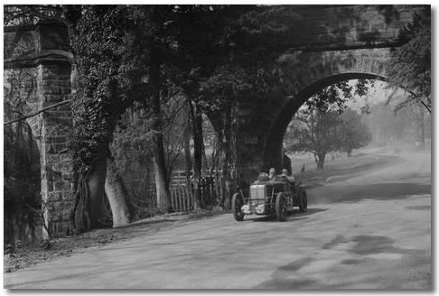
In the topographical maps we see that Starkey's Hill was a high point, as was Coppice Wood, with the Starkey's Bridge in the valley between the two. One map shows Starkey's Bridge being so-called before racing commenced in the '30s. The OS 25 map dated 1892-1914 shows the "lane" as a dotted line, but shows the bridge as a solid structure with what appears to be a solid structure at both ends of the bridge.


Now why is this important?


The bridge was built in 1834. The whole Castle Donington parish had been undergoing an increase in population from the very late 16th century with not only wood and paper mills doing a roaring trade , but lace making had taken off, also requiring an increase in workers. The plantations such as Cliff Hill, Ramsley Wood, All Hooks, Thirteen Acre and Holly Wood were all producing good yields and needed an increase in good access roads, both for goods and workers. I imagine workers came from Castle Donington across the bridge to work the mills and wharves along the River Trent. The 1937-61 map shows a miriad of access pathways within all the plantations, all connecting to the main "Starkey's Bridge lane".  A couple of the maps from Geoff's link have FB next to the structure - so "foot bridge"?


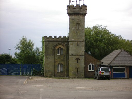
Donington Hall became the social hub of the parish and also flourished during this time with many improvements. Recreationally, the Hall became the centre for the entire county for fox and deer hunting.


Sadly, as the years went on, the plantations yielded all they could, the Mills closed and the lace making industry self destructed due to "twist net fever" (that's another story) so by the late 1840's little remained of any viable industry, so workers moved away. Donington Hall was sold off many times, with poor management seeing it reduced to basically a "holiday house" for some of its wealthier owners.


The ownership history is a fascinating story in itself, but I don't wish to bore you any more.


I know much of this is supposition, but I hope you find it as interesting I have.


Cheers, Steve


PS: Who was Starkey? I still have no idea!


Edited by Porsche718, 19 April 2018 - 10:54.


#49 Vitesse2

Vitesse2
  • Administrator

  • 41,869 posts
  • Joined: April 01

Posted 19 April 2018 - 11:47

Again speculation, but I wonder if Starkey is a corruption of 'Starkby'? There are lots of Old Norse-derived place names in Leicestershire and the -by ending is roughly the equivalent of -ham or -ton in English. So Starkby would mean 'the farm [or settlement] of Stark'. 'Stark' in both Old Norse and Old High German means 'strong'.


http://www.thiswasle...estershire.html


https://www.nordicnames.de/wiki/STARK


Checking that would probably mean going back a long way to mediaeval tithe maps or even Domesday Book!


#50 Charlieman

Charlieman
  • Member

  • 2,545 posts
  • Joined: October 09

Posted 19 April 2018 - 12:23

The bridge was built in 1834. The whole Castle Donington parish had been undergoing an increase in population from the very late 16th century with not only wood and paper mills doing a roaring trade , but lace making had taken off, also requiring an increase in workers. The plantations such as Cliff Hill, Ramsley Wood, All Hooks, Thirteen Acre and Holly Wood were all producing good yields and needed an increase in good access roads, both for goods and workers.

Not really. The bridge location is a "soggy bottom" where underground and overground streams meet, creating the open water with weirs shown on some maps. The bridge is most likely to have been an architectural folly, an entertaining water and stone feature to impress visitors at the hall. The weirs may have been built to contain fish in what is essentially a pond. It is unlikely that commercial traffic would use a lane or track so close to the hall.


I live 20 miles south of Donington Park, close to a flood plain. Boggy land is still crossed by a pack horse bridge dating back to mediaeval times (probably earlier) which was used until the early industrial revolution for transporting goods into the city of Leicester. I assume that a pack horse bridge (low arches) would be sufficient to cross a soggy bottom, rather than Starkey's Bridge which would seem appropriate in scale for a market town. Or just go around the boggy land -- the woodland around the pond suggests that it wasn't too wet. 


The land close to me was used during WWII, at different times and places, as an assembly area for D-Day vehicles, scrap yard and tented billets for GIs. They thought differently in those days. I can easily imagine 50,000+ vehicles parked at Donington -- you get a couple of thousand classic cars parked around and about in exhibitions at current events.